 |
(of
six)
South America - Antarctica
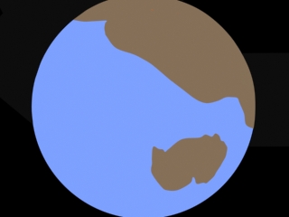
Analysis of the Pacific seafloor leads me to position East Antarctica below the protocontinent, as explained on the Even Earlier page.
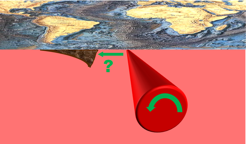
The force of the meteorite impact peeled a strip of land away from southern Africa. Madagascar was at the end of this strip, but it broke off almost immediately. As the long branch swung down, it pulled South America away from Africa, widening as it progressed. The shock wave pushed up low mountains on the east edge of South America (Brazilian Highlands). Leverage split North America from Africa and Europe and raised low mountains on South America's north side (Guiana Highlands). When the end of the branch struck East Antarctica at an angle, East Antarctica rotated counterclockwise. This pulled the end of the long branch and stretched it. When it finally split, the broken tips carved out the Scotia Trench. The Kerguelen Plateau marks the leading edge of East Antarctica where it had come to a halt long before, when the braking effect of the leading edge may have caused this part of East Antarctica to dig into the oceanic crust. Rotating away opened this thinned area, allowing flood basalts to pour out.
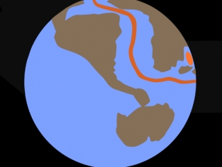
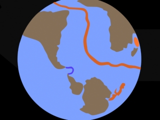
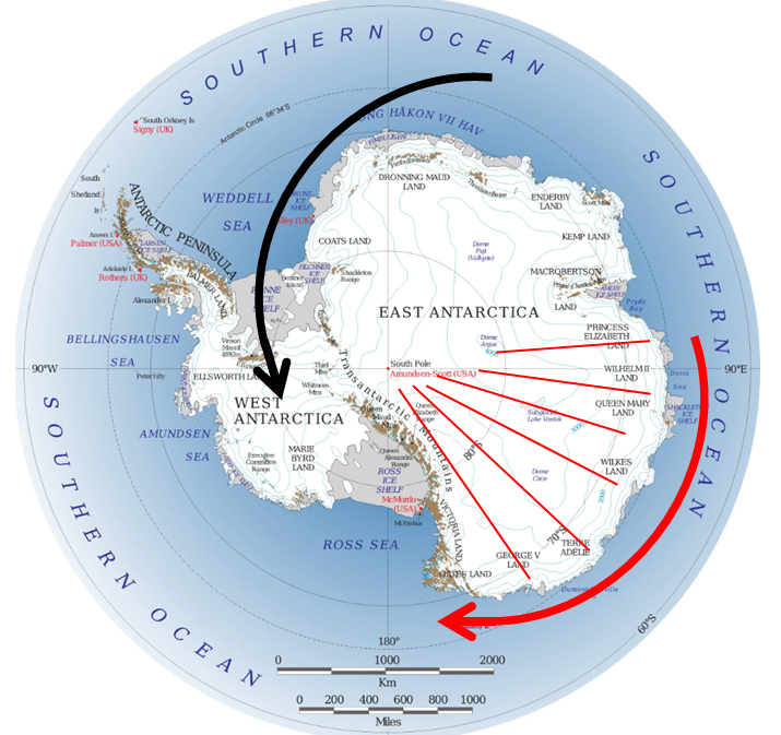
In the illustrations above, West Antarctica only appears to be growing larger after its collision with East Antarctica because it is breaking into pieces and stretching, as shown below.
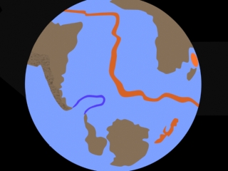
Remarkably, the rotation of East Antarctica is recorded in the bedrock! As the continent was spun counterclockwise by the blow from West Antarctica, the part that was pulled away opened valleys, like the opening of a folding fan.

" international compilations of radio-echo sounding data have resolved large-scale subglacial topographic features in increasing detail, revealing a wide and low-elevation sector of East Antarctica extending from Prydz Bay to the Transantarctic Mountains and from the coast inland to 85 degrees South. In this region, most of the large subglacial basins are V shaped". "At a semi-continental scale, the topography resembles a handheld fan, converging to a point located close to the South Pole. We propose that the entire region is a single physiographic unit and name it the East Antarctic Fan-Shaped Basin Province (EAFBP)." " the Antarctic Ice Sheet covers more than 99% of the continent." " these basins underlie about half of the East Antarctic Ice Sheet". The researchers "propose that it formed through large-scale rotational extensional tectonics". "Since no evidence of EAFBP continuation is found in Australia, the fan-like rotational extension must have been confined to the Antarctic lithosphere."9
However, in the Plate Tectonics version Antarctica (red dot) does not rotate, so that theory struggles to explain the clear findings.
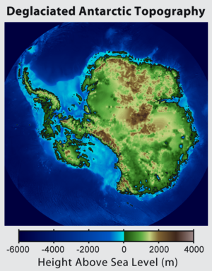
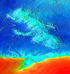
The high cliffs that run along the left edge of East Antarctica in the image below are an unusual mountain range. These Transantarctic Mountains were not formed by lateral compression but by curling up.7 "...the Transanarctic Mountains are the largest non-compressional mountain belt in the world".9 It suggests that East Antarctica was formerly part of a larger whole that was clipped along the line of the mountains, as proposed in this scenario. Microtektites from the Transantarctic Mountains (Victoria Land) fit the geochemical signature of the Australasian strewn field,3 the world's largest and in the right place for the Shock Dynamics model. Tektite strewn fields result from meteorite impacts. Nearly all have been matched with a particular crater, but none has ever been found for the Australasian strewn field, till now. Finally, the big difference in thickness between West (25 km) and East (40 km) Antarctica6, clearly seen in this image, suggests that they did not originate together but were brought together.
Study of the Kerguelen Plateau indicates that it is a "stretched continental fragment overlain by basaltic flows"5, which is consistent with it originating under East Antarctica. Furthermore, it displays "extension of the crust in the NNW-SSE direction"5, in accordance with the counterclockwise rotation of East Antarctica.
The way the South American east coast matches the African west coast led anyone who noticed it to wonder if the two continents had once been joined, which in turn led to theories of continental drift. The Shock Dynamics model explains even more about South America.
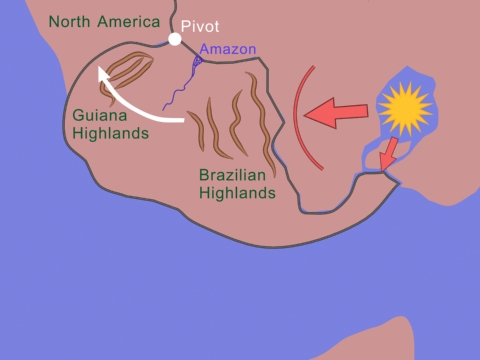
The force of the impact peeled a narrow strip of land off of Africa, beginning with Madagascar. But Madagascar quickly broke off when it was pulled out by Australia. As the strip of land swung down, the rest of South America was peeled off of Africa, pivoting on a point far to the northwest. This ripped open the mouth of the Amazon River and punched Venezuela into North America, raising the Guiana Highlands. The shock wave from the exploding meteorite ran quickly across the narrow center of Africa to raise extensive low mountains (Brazilian Highlands) and push South America westward. Evidence shows that the Amazon River originally flowed from east to west4 as the sea poured in. After the Andes Mountains rose up, flow reversed; today it is west to east.
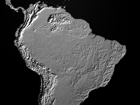
Thus we would expect to find uplifted land aligned east-to-west in northwestern South America, and we do; the Guiana (or Guyana) Highlands have peaks as high as 6890 to 9888 feet. Little attention has been paid to the tectonics of this area, due in large part to the difficulty of travelling to it. Researchers attribute magmatism and rifting in the Guyana shield to the opening of the Atlantic Ocean.2
According to Plate Tectonics, South America and Africa consist of islands of land that drifted into each other. The mountains of eastern Brazil were raised as the islands collided. Whether that happened between 730 and 550 million years ago during the assembly of the supercontinent Gondwana,1 or 2.1 to 2.0 billion years ago during the assembly of the supercontinent Columbia8 is debated. One wonders why, when the Atlantic was opened during the breakup of Pangea, the crust divided across solid cratons (Sao Francisco-Congo and West Africa cratons1) rather than along the supposed island boundary sutures.
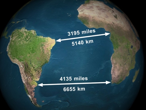
The southern end of South America is almost 30% farther from Africa than the northern end. It pivoted like a swinging gate. If only the continental crust moved, as proposed in the Shock Dynamics model, there is no problem. But for Plate Tectonics, there are big problems.
Mantle convection below the South Atlantic would have to be conical-shaped to match the progressively faster speed of the South American Plate towards its southern end. But convection can't be driving the movement, because the slab that is diving below the west coast of South America blocks mantle flow, and it is not bent away. So this mantle convection must be passive. The only plate-driving forces left to Plate Tectonics here are ridge push and slab suction. The first requires progressively greater mid-ocean ridge formation towards the south, and the second requires the Nazca and Antarctic plates to be subducting progressively faster towards the south. Both these options are ridiculous. On top of that, none of these driving forces are capable of raising a mountain chain by compression of the continental crust. The movement of South America away from Africa is clear evidence that the Shock Dynamics model is superior to Plate Tectonics theory.
![]()
1. Alkmim, Fernando F., Stephen Marshak, Marco A. Fonseca. April 2001. Assembling West Gondwana in the Neoproterozoic: Clues from the Sao Francisco craton region, Brazil. Geology, Vol. 29, No. 4, pp. 319-322.
2. Almeida, Fernando Flavio Marques de, Benjamim Bley de Brito Neves, Celso Dal Re Carneiro. 2000. The origin and evolution of the South American Platform. Earth-Science Reviews, Vol. 50, pp. 77-111.
3. Folco, L., P. Rochette, N. Perchiazzi, M. D'Orazio, M.A. Laurenzi, M. Tiepolo. April 2008. Microtektites from Victoria Land Transantarctic Mountains. Geology, Vol. 36, No. 4, pp. 291-294.
4. Mapes, Russell W., Afonso C.R. Nogueira, Drew S. Coleman, Angela Maria Leguizamon Vega. 2006. Evidence for a Continent Scale Drainage Inversion in the Amazon Basin since the Late Cretaceous. Geological Society of America, Abstracts with Programs, Vol. 38, No. 7, p. 518.
5. Operto, Stephane, Philippe Charvis. November 10, 1996. Deep structure of the southern Kerguelen Plateau (southern Indian Ocean) from ocean bottom seismometer wide-angle seismic data. Journal of Geophysical Research, Vol. 101, No. B11, pp. 25,077-25,103.
6. Sieminski, Anne, Eric Debayle, Jean-Jacques Leveque. 2003. Seismic evidence for deep low-velocity anomalies in the transition zone beneath West Antarctica. Earth and Planetary Science Letters, Vol. 216, pp. 645-661.
7. ten Brink, Uri S., Ron I. Hackney, Stephen Bannister, Tim A. Stern, Yizhaq Makovsky. December 10, 1997. Uplift of the Transantarctic Mountains and the bedrock beneath the East Antarctic ice sheet. Journal of Geophysical Research, Vol. 102, No. B12, pp. 27,603-27,621.
8. Zhao, Guochun, Min Sun, Simon A. Wilde. 2002. Did South America and West Africa Marry and Divorce or Was it a Long-lasting Relationship? Gondwana Research, Vol. 5, No. 3, pp. 591-596.
9. Armadillo, Egidio, et al. 3 June 2026. A fan-shaped subglacial basin province in East Antarctica formed by rotational extension. Nature Geoscience DOI:10.1038/s41561-026-01991-6