 |
North America
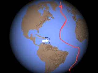
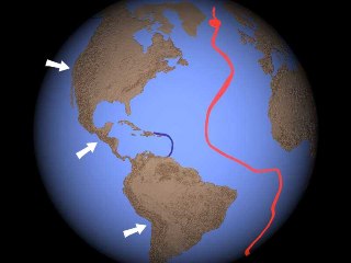
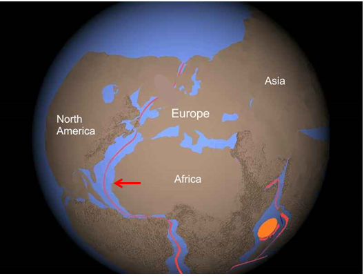
The shock wave raised the Appalacian Mountains in the push off from Africa. Central America unfolded from between North and South America. Greenland and the Northern Canadian Islands broke away from North America as it moved west. A trench formed when the Antilles was pulled off of South America. Friction along the entire leading edge built major mountain chains and stopped all movement.
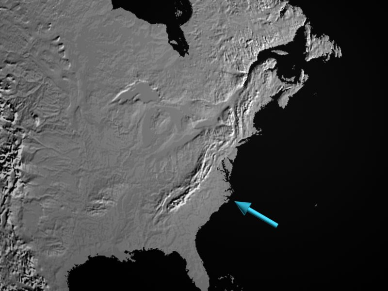
The Appalachians exemplify impulse mountains raised at the beginning of the Shock Dynamics event. Folding of these mountains was caused by pressure from the shock wave initiated by the giant meteorite impact east of Africa. This is borne out by a specialist in Appalachian geology who wrote, "maximum orogeny [mountain building] took place in a linear core belt... These rocks, and any floor on which they may have rested, were as if gripped and squeezed between the jaws of a giant vise, and at the same time heated up enough to become quite plastic and to stew in their own juice, in the fluids released as they transformed into mineral assemblages." "...for me the vise is not a metaphor but a fairly exact model. Thus the evidence of intense shortening perpendicular to the length of the chain, not only in the folded marginal belts but also in the central core belt, is too clear for me to doubt that there was not only confining but directed pressure, the greatest compressive stress being consistently directed roughly horizontally across the orogenic belt." "Compression then relaxed, and the thickened crust rose isostatically to form mountains and has continued to do so ever since." As a believer in Plate Tectonics, he could not find a mechanism in the crust that could do this, but imagined mantle convection must be involved.-- Rodgers, John. 1970. The Tectonics of the Appalachians. John Wiley & Sons, Inc., New York. p. 224.
Apparently
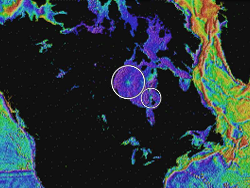
there were already two large meteorite impact craters in the protocontinent
before the Shock Dynamics event. Though Hudson Bay opened
up as North America moved, their forms and central peaks can still
be seen.
Brookfield,
Michael E. 2003. The Eastern Hudson Bay Arc, Canada: part of a multi-ringed
impact basin. in: Third International Conference
on Large Meteorite
Impacts, August 5-7, 2003, Nordlingen, Germany. p. 4010.
Hudson Bay has been a puzzle for Plate Tectonics. These are conclusions from a 2021 study: "Hudson Bay occurs directly above the subcontinental lithospheric mantle keel of North America." "Tomography data reveal a vertical axial zone in the lithosphere beneath Hudson Bay, which extends from the lithosphere-asthenosphere boundary to the base of the crust or, perhaps, even to the present day surface. The zone is made up of relatively light low-velocity igneous boundary rocks." "The structure of subcontinental lithospheric mantle beneath the bay was produced through the effects of a succession of mantle plumes."
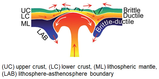
Mints, Michael V., Ksenia A. Dokukina, Tamara B. Afonina. 20 January 2021. Precambrian lithosphere beneath Hudson Bay: A new geological model based on the Hudson Bay Lithospheric Experiment (HuBLE), Canadian Shield. Tectonophysics, Vol. 799, 228701. DOI:10.1016/j.tecto.2020.228701
However, there is no tomographic evidence of mantle plumes beneath Hudson Bay. Where did they go?
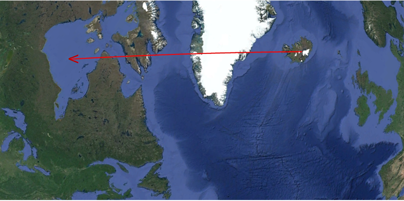
In Shock Dynamics, the Hudson Bay meteorite impacts struck where Iceland is today. When North America moved rapidly west, the pressure relief led to an outpouring of magma that formed Iceland. So the surface features are in Hudson Bay; the deep features are in Iceland. If it had happened at a slow, Plate Tectonics pace, there would have been a wide magmatic trail between the two.
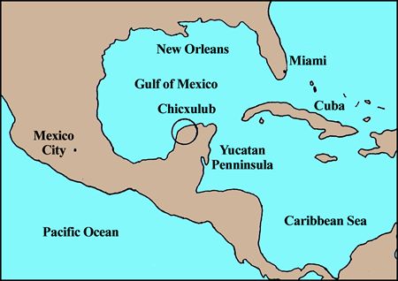
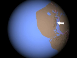
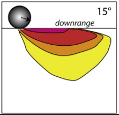
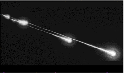
The Chicxulub meteorite impact crater is on the northern edge of the Yucatan Peninsula. The meteorite apparently struck at a low angle, leaving features similar to an oblique impact on Mars, imaged (below right) by the High Resolution Imaging Science Experiment camera on the Mars Reconnaissance Orbiter. The arrow shows the direction of travel of the meteorites that formed both craters. The Mars picture has been turned for the purpose of comparison, but the Chicxulub crater is oriented as it is on Earth.
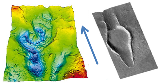
Despite the clarity of the image, researchers have had different opinions on the direction of travel of the Chicxulub meteorite. A study of particles in the center of the crater produced the chart below showing their orientation to be southeast to northwest in the Yucatan Peninsula's current position. That indicates the line of travel, in the crater's present position.
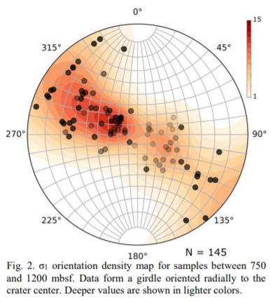
Ebert, M.,
M. H. Poelchau, T. Kenkmann, Ritu Sah. 2019. Feather Features in Shocked Quartz
as a Tool to Constrain Deformation in Impact Craters: A Case Study of Chicxulubs
Peak Ring. 50th Lunar and Planetary Science Conference, LPI Contribution No.
2132, Abstract No. 2465.
Comets and asteroids entering the solar system tend to align with the orbits of the planets in the plane of the ecliptic due to the pull of gravity. It is extremely unlikely that an object would ever collide with Earth while travelling perpendicular to Earth's orbit, so we would not expect to see a meteorite crater oriented southeast to northwest.
So what happened? Plate Tectonics has no answer, but Shock Dynamics does:
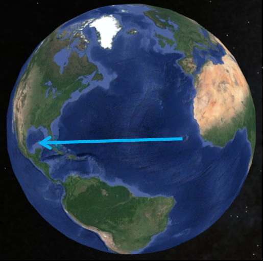
Before the event, the Yucatan Peninsula was turned 145 degrees clockwise from the way it is now, folded in with the rest of Central America in the protocontinent. The Chicxulub meteorite, travelling west to east, struck the protocontinent and weakened the continental crust there. When North and South America moved west during the Shock Dynamics event, Central America separated from Africa at that point, opening up to its current position in which the Chicxulub crater is oriented southeast-to-northwest.
We can see where the Chicxulub impact left a mark in the crust where it hit. That place is the Cape Verde volcanic islands.

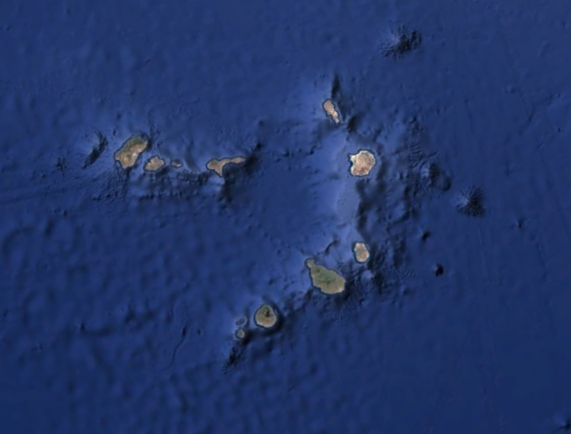
The Cape Verde Islands remained behind when the Chicxulub crater on the Yucatan Peninsula was drawn far to the west with North America during the Shock Dynamics event.
These islands are in the right place off the west coast of Africa, at the right latitude, the right shape and arc-orientation, and the right size (the length of the yellow line equals the diameter of the Chicxulub crater).
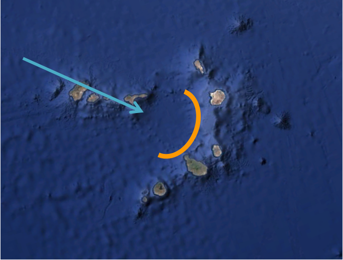
The Chicxulub crater was apparently made by a low-oblique impact, inclined perhaps 15 degrees. That means much of the impact energy near the surface was directed towards the downrange end.
Notice that the Chicxulub crater is open-ended on the downrange side. The Cape Verde volcanic islands complete the crater in its original orientation, where impact energy forced magma up from below.
![]()
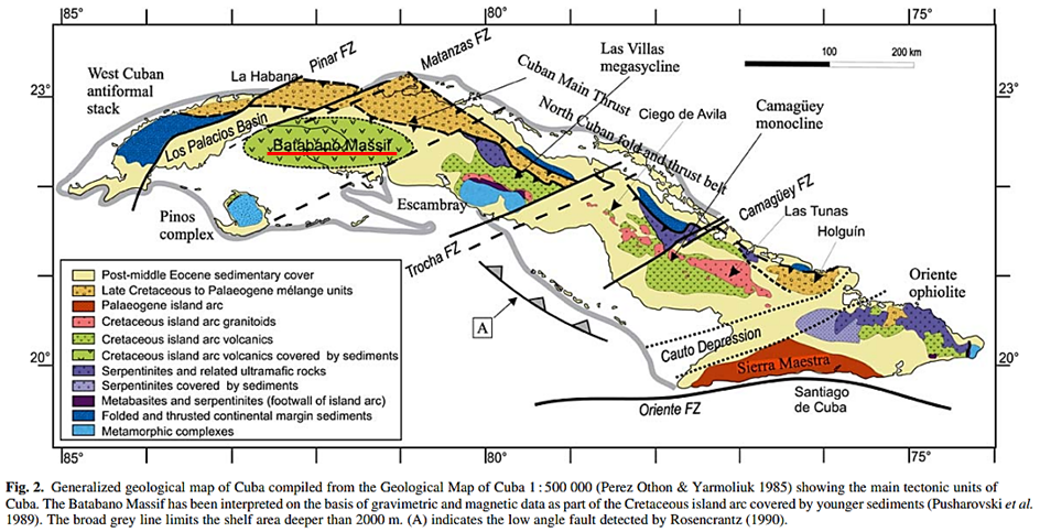
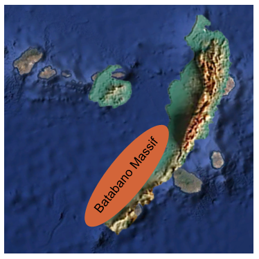
The Cape Verde volcanic islands are in oceanic crust. Let's look at continental crust. When the Chicxulub impact occurred, the western part of Cuba was attached to the Yucatan Peninsula in the Shock Dynamics reconstruction. A geologic map of Cuba shows the approximate extent of deep melt from the impact - the Batabano Massif.
The Pinos metamorphic complex is unique in Cuba because its high-grade metamorphic rocks formed at a peak temperature of around 750° Centigrade and 11-12 kilobar pressure, "and then underwent strong decompression". It "is a coherent metamorphic complex that probably represents a portion of the continental margin of the Yucatan Block during the Mesozoic." - Garcia-Casco, A., R.L. Torres-Roldan, G. Millan, P. Monie, F. Haissen. November 2001. High-grade metamorphism and hydrous melting of metapelites in the Pinos terrane (W Cuba): Evidence for crustal thickening and extension in the northern Caribbean collisional belt. Journal of Metamorphic Geology, Vol. 19, No. 6, pp. 699-715 DOI:10.1046/j.0263-4929.2001.00343.x
This is a topographic map of Cuba.
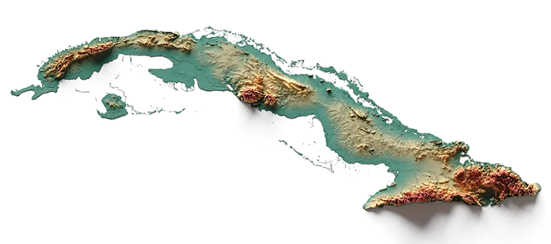
At the western end are the Sierra del Rosario and Sierra de los Organos chain. The Island below them is the Pinos metamorphic complex.
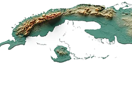
This is how western Cuba and the Cape Verde volcanic islands look on Googe Earth. They are similar in size.
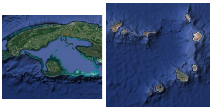
Below is an overlay of the Sierra del Rosario, the Sierra de los Organos, the Batabano Massif, and the Pinos metamorphic complex onto the Cape Verde volcanic islands.
Shock Dynamics theory explains what Plate Tectonics theory cannot.
Here are excerpts from two studies of the area. The first finds lithospheric anomalies that are, you might say, off the charts. The islands are on elevated crust called the Cape Verde Rise. The researcher is at a loss as to what could have reheated the lithosphere to such a degree. Energy released by the Chicxulub impact would have been sufficient.
"The Cape Verde Rise represents an extreme case of the process of oceanic midplate volcanism. The regional depth and geoid anomalies relative to the plate model are the largest observed.The effective elastic thickness for the plate supporting the volcanoes is 28+4 km and the compensation depth for the broad swell is 69+10 km. These two results, combined with heat flow observations from the rise, are consistent with a model for reheating of the lithosphere beneath Cape Verde such that the average thermal gradient is increased by about 35%. While there is no doubt that the Cape Verde lithosphere has been reheated, it is unlikely that the entire depth anomaly is explained by thermal anomalies confined to the lithosphere. There are no permissible thermal models fitting all of the geophysical data that do not require either dynamic support from or elevated temperature within the asthenosphere." -- McNutt, Marcia. 10 April 1988. Thermal and mechanical properties of the Cape Verde Rise. Journal of Geophysical Research, Solid Earth, Vol. 93, No. B4, pp. 2784-2794. DOI:10.1029/JB093iB04p02784
The second study concludes that there is something unusual underneath the Cape Verde islands - the type of mantle that is found below cratons, which are considered to be ancient continental crust. Apparently the Chicxulub impact was large enough to at least partially melt the subcrustal mantle, allowing some elements to differentiate to the point where it now resembles subcontinental lithospheric mantle. That is a more reasonable explanation than what the researchers speculate.
"The Cape Verde Islands lie in the Atlantic Ocean off West Africa, in a clearly oceanic setting." "...data and seismic tomography suggest that part of the Cape Verde Archipelago is underlain by a fragment of ancient subcontinental lithospheric mantle, left stranded in the oceanic lithosphere during the opening of the Atlantic Ocean." -- Coltortia, Massimo, Costanza Bonadiman, Suzanne Y. O'Reilly, William L. Griffin, Norman J. Pearson. November 2010. Buoyant ancient continental mantle embedded in oceanic lithosphere (Sal Island, Cape Verde Archipelago). Lithos, Vol. 120, No. 1-2, pp. 223-233. DOI: 10.1016/j.lithos.2009.11.005
More Chicxulub?
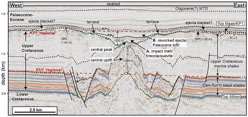
An August 2022 report found a meteorite impact crater on the west coast of Africa that the authors say could be associated with the Chicxulub impact, either by the breakup of the Chicxulub meteor in the atmosphere or as part of a swarm of meteors. They named it the Nadir Crater after a nearby seamount. This is its seismic cross section:
From: Nicholson,
Uisdean, Veronica J. Bray, Sean P. S. Gulick, Benedict Aduomahor. 17 August
2022. The Nadir Crater offshore
West Africa: A candidate Cretaceous-Paleogene
impact structure. Science Advances, Vol. 8, No. 33 DOI:10.1126/sciadv.abn3096
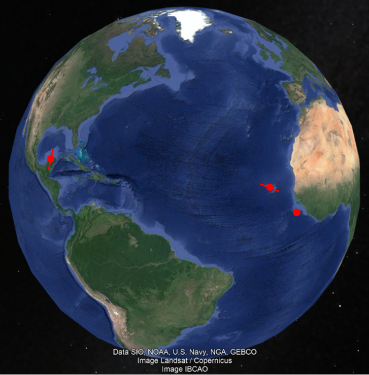
However, Nadir Crater is 4,800 miles away from the northern Yucatan Peninsula, and the current orientation of the Chicxulub Crater is southwest-northeast. The Cape Verde Islands, on the other hand, are only 650 miles away, over 7 times closer to the Nadir Crater. And the orientation is a better fit to a dual impact.
![]()