 |
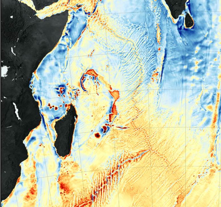
Section
of a 2014 marine gravity anomaly map derived from satellite altimetry
by David T. Sandwell, R. Dietmar Muller, Walter H. F. Smith, Emmanuel
Garcia, and Richard Francis. From:
https://earthobservatory.nasa.gov/images/87189/seafloor-features-are-revealed-by-the-gravity-field
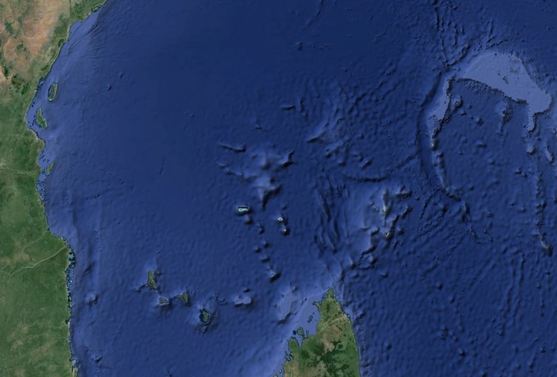
From
Google Earth
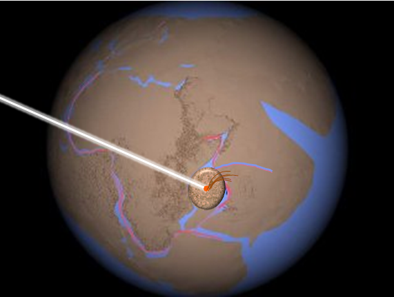
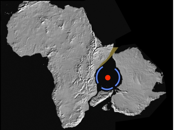
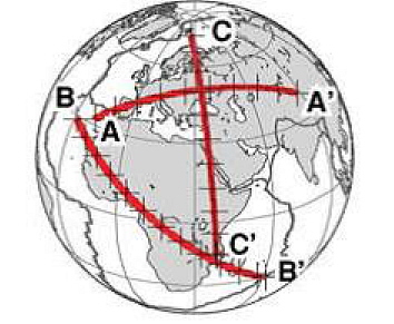
The mound
in the middle is Wilkes Guyot, the center of the crater's central
uplift.
The radius of the circle of continental crust
removed by the impact is the distance from Wilkes Guyot to
the
northern tip of Madagascar (500 km or 311 miles), so the
blast-crater diameter is about 1000 km or 621 miles.
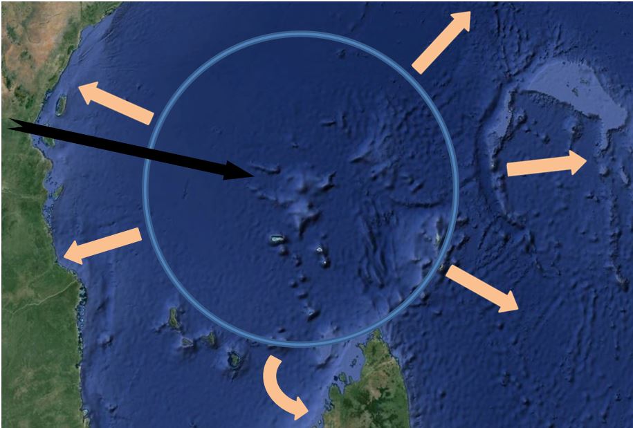
Circle:
approximate blast-crater; Black arrow: meteorite trajectory;
Beige
arrows: Pushed out continental crust
Evidence indicates that the impact
angle was about 30 degrees above the horizon,
headed east-southeast:
1) Only oblique impacts produce side
blowouts.
2) The largest tektite strewn fields are made by
30-degree impacts1,
and the associated Australasian strewn field covers 10% of the earth.
3) There is an east-southeast breach in the central peak.
Such breaches are parallel to the meteorite's trajectory.4
4) "In oblique impacts the strength of the shock is asymmetric,
with the strongest shock in the downrange direction."3
The downrange shock wave produced the Tonga and Mariana Trenches.
5) The central peak is fairly centered in the crater. The
position of a central peak is not affected by the impact angle.2
6) As discussed elsewhere on this website, the South Pacific
Superswell is likely an antipodal effect of the impact, offset due
to the obliquity of the impact.
1. Artemieva, N. 2008. Tektites: Model Versus Reality.
39th Lunar and Planetary Science Conference, p. 1651.
2. Ekholm,
Andreas G., H. Jay Melosh. February 15, 2001. Crater features diagnostic
of oblique impacts: The size and position of the central peak. Geophysical
Research Letters, Vol. 28, No. 4, pp. 623-626.
3. Pierazzo,
E., H. J. Melosh. 2000. Melt Production in Oblique Impacts. Icarus,
Vol. 145, pp. 252-261.
4. Schultz, P.H., R.R. Anderson.
1996. Asymmetry of the Manson impact structure: Evidence for impact
angle and direction, in The Manson Impact Structure, Iowa: Anatomy
of an Impact Crater. C. Koeberl and R.R. Anderson (eds). Geological
Society of America Special Paper 302, pp. 397-417.
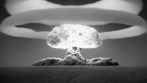
The giant meteorite had penetrated completely through the continental crust when it exploded, transferring its energy directly to the surrounding crust. Some debris went straight up, like this underground nuclear explosion,
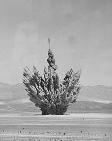
unlike a surface explosion, which spreads devastation across a wide area.
Putting the scattered pieces of Earth's crust back together reveals the hole where the giant meteorite vaporized and excavated the continental crust, including the side blowouts. Based on the distance from the center to the Comoros and Amirante Trench, the crater was over 600 miles in diameter. By comparison, Chicxulub crater is 112 miles in diameter.
The remnants of the crater walls can still be seen as rounded cuts on the coasts of East Africa, northern Madagascar, and southern Australia
The
impact was onto continental crust. But as the land separated,
the ocean rushed in and obliterated the crater rim. This is
typical for craters in the ocean.
Dypvik, Henning, Lubomir F. Jansa. 2003. Sedimentary signatures
and processes during marine bolide impacts: a review. Sedimentary
Geology, Vol. 161, pp. 309-337.
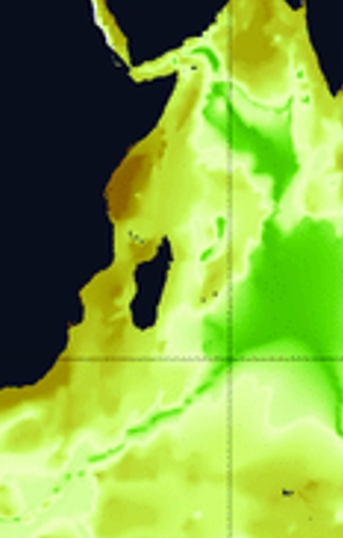
Yet some effects are evident on the west side. The coasts of Kenya and Tanzania show severe faulting and diapirism (cracks into which magma seeped). The continental shelf is quite narrow (25 to 50 km), with a steep continental slope. Numerous normal (pull-apart) faults are downthrown to the east. There is a major sediment slide 8 kilometers thick.1 Such partial collapse is typical of impacts on the continental margin.2
1. Coffin, M.F., P.D. Rabinowitz. 1988. Evolution of the conjugate East-African-Madagascan margins and the Western Somali Basin. Geological Society of America Special Paper 226.
2. Dypvik, Henning, Lubomir F. Jansa. 2003. Sedimentary signatures and processes during marine bolide impacts: a review. Sedimentary Geology, Vol. 161, pp. 309-337.
From:
Lipp, Julius. 2008. Intact membrane lipids as tracers for microbial life in the
marine deep biosphere.
Doctoral dissertation in natural science, University of
Bremen. http://elib.suub.uni-bremen.de/diss/docs/00011010.pdf.
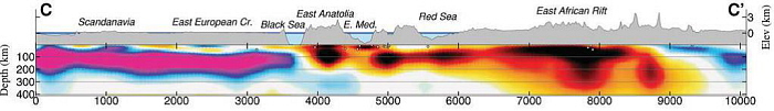
Global seismic tomography shows the depth and extent of the damage of the impact. The cross-section C to C' (below) passes through East Africa. C' is the part of Africa nearest the impact site.
Here is what the tomographic cross-section reveals:
|
Notice that the hottest rock (black) is below the East African Rift. It reaches a depth of 300 km and can be detected down to 585 km. Where along the East African Rift is this deep hot zone? The 485 km-deep horizontal cross-section below pinpoints it. |
|
|
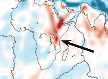
It
is right where we expect it - at the point of maximum damage.
Schaeffer,
A.J., S. Lebedev. 2013. Global shear speed structure of the upper
mantle and transition zone. Geophysical Journal International, Vol.
194, pp. 417-449.
We would expect that the shock wave would produce high-pressure metamorphism in the rocks of east Tanzania, and that is what we find: "Peak metamorphic conditions are surprisingly similar over a very large area", about 140,000 square kilometers! High-pressure granulite facies metamorphism is evident throughout the Pan-African mobile belt of East Africa. Note that Plate Tectonics theory sees this as an area where crust separated rather than being crushed together before splitting.
Appel, P., A. Moeller, V. Schenk. 1998. High-pressure granulite facies metamorphism in the Pan-African belt of eastern Tanzania: P-T-t evidence against granulite formation by continent collision. Journal of Metamorphic Geology, Vol. 16, No. 4, 491-510.
Regrettably, the West Somali Basin basalt floor has scarcely been sampled. Drilling was attempted at two sites (240 and 241) in 1972 as part of the Deep Sea Drilling Project. The drill bit broke after penetrating just 1.2 meters into basalt at site 240, and never reached basalt at site 241. No one ever tried again.
![]()