|
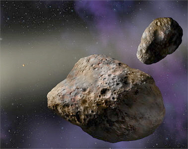
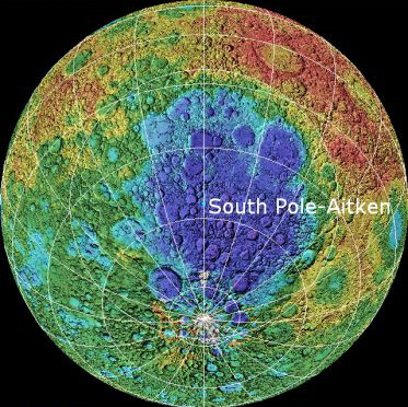
Early in its existence, "data suggest there was an impact cataclysm that affected the entire inner solar system, resurfacing the terrestrial planets, and that the source of the impacting debris was the asteroid belt. Comets do not appear to have been important."1 Another study concludes that a chondritic asteroid about 170 km in diameter broke up much later, and that its pieces fell on the terrestrial planets. That surge of impacts included the catastrophic Chicxulub meteorite at the Cretaceous/Tertiary (K/T) boundary.2 1. Kring, David A., Barbara A. Cohen. 2002. Cataclysmic bombardment throughout the inner solar system 3.9--4.0 Ga. Journal of Geophysical Research, Vol. 107, No. E2, pp. 4-1 to 4-6. 2. Bottke, William F., David Vokrouhlicky, David Nesvorny. 6 September 2007. An asteroid breakup 160 Myr ago as the probable source of the K/T impactor. Nature, Vol. 449, pp. 48-53. Large Impacts On the Moon South Pole-Aitken is the biggest basin on the Moon, at over 2,600 km across and 12 km deep. In the Solar System it is second in size only to the Borealis basin on Mars. "The chemical composition of material within lunar craters, as well as their size distribution, matches nicely with asteroids, not comets." Hand, Eric. 26 June 2008. The hole at the bottom of the Moon. Nature, Vol. 453, pp. 1160-1163.
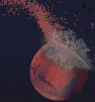
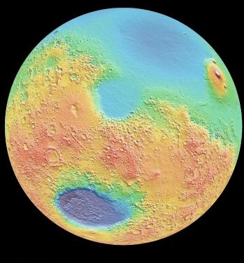
"Since their discovery in 1877, determining the origin of [Mars' moons] Phobos and Deimos has remained problematic." Some evidence "has led many investigators to suggest that they are captured asteroids. However, the orbits of both moons are extremely circular and their Laplace plane is very close to the martian equatorial plane. Captured objects would be expected to have elongate orbits with randomly oriented orbital planes." "An alternative hypothesis that is frequently overlooked is the possibility that Phobos and Deimos are the result of a giant impact." There is also the fact that, "similar to the Earth-Moon system, Mars has too much angular momentum" "to be explained by the accretion of many small bodies." "A planetesimal with 0.02 Mars masses must have collided with that planet early in its history in order for Mars to spin at its current rate." "The number of impact basins on Mars support the idea that large objects struck its surface early in its history, including evidence that a giant impact formed the Borealis basin and created the martian dichotomy."1 "Mars is a divided planet. Its southern highlands cover about 2/3 of the planet and are on average about 4 km higher than the northern plains, a difference that is known as the hemispheric dichotomy."2 The light blue part of Mars in the image on the right are the northern plains. Long thought to have been a product of mantle circulation, evidence now shows that the region is probably the result of the largest impact in the Solar System (artist's conception on the left). The elliptical shape, close to 10,650 km by 8,520 km, had made it seem unlikely to be an impact crater since impact craters are usually round. However, "Small impact craters are essentially formed on a flat surface."2 But for an impact large enough to make the hemispheric dichotomy, the curvature of the planet comes into play. A simulation determined that the colliding asteroid had a diameter in the range of 1,600-2,700 km, travelled at 6-10 km/s, and struck at an angle between 30 and 60 degrees.4 Mars itself has a diameter of 6,780 km.2 The dark blue basin near the bottom of the image on the right is the Hellas basin. It was also formed by an impact, but is only 2,300 km across.2
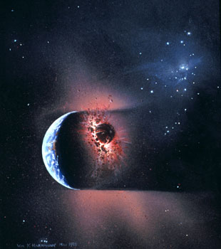
The original crust of Mars likely formed in the same way Earth's did, by surface cooling of a magma ocean. This produces basalt, which is the oceanic crust of Earth. A team studying the northern plains of Mars believe "the northern lowlands crust, by contrast, probably arose primarily from shock melting in the deep and previously depleted martian mantle." "Impact melting occurs because of decompression following the initial shock". "The volume of crust missing from the northern lowlands is about 1.5 x 10⁹ km3." "The total melt volume produced during the impact is 6 x 10⁸ km3."4 "Planetary-scale impacts penetrate into the mantle. The resulting rarefaction wave completely removes the surrounding crust, which re-impacts elsewhere on the planet or is ejected to space."3 Simulation results show that "depending on impact angle, 50--70% of the melt stays inside the excavated boundary, 25--30% is deposited outside the boundary, and the remainder is ejected from the planet."3 "Depending on impact energy and initial crustal thickness, a basin may be retained or impact-induced crust may be topographically elevated."5 "Numerical simulations of giant impacts on Mars indicate that impact energies of 3 x 1028 to 3 x 1029 J are capable of excavating a basin with size comparable to the northern lowlands without generating so much melt that the crust is flooded and the basin erased." "If post-impact crust is thinner than the initial crust, a basin is retained".5 1. Craddock, Robert A. February 2011. Are Phobos and Deimos the result of a giant impact? Icarus, Vol. 211, No. 2, pp. 1150-1161. 2. Kiefer, Walter S. 26 June 2008. Forming the martian great divide. Nature, Vol. 453, pp. 1191-1192. 3. Marinova, Margarita M., Oded Aharonson, Erik Asphaug. 26 June 2008. Mega-impact formation of the Mars hemispheric dichotomy. Nature, Vol. 453, pp. 1216-1219. 4. Nimmo, F., S.D. Hart, D.G. Korycansky, C.B. Agnor. 26 June 2008. Implications of an impact origin for the martian hemispheric dichotomy. Nature, Vol. 453, pp. 1220-1223. 5. Reese, C.C., C.P. Orth, V.S. Solomatov. 2011. Impact megadomes and the origin of the martian crustal dichotomy. Icarus, Vol. 213, pp. 433-442. On early Earth, to form the Moon and continental crust Today, standard theory says the Moon formed from debris kicked out into space when a planetesimal about the size of Mars grazed the Earth.
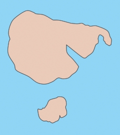
"For sufficiently large impact energy (for example, on the order of that for the Moon-forming impact [on Earth] of around 1031 J), retention of an impact basin is unlikely." Would a global magma ocean form? "For impact energies that are not too large, global magma ocean formation may be difficult due to rapid crystallization of impact melt and further cooling during lateral spreading."4 "Vigorous convection of low-viscosity liquid silicates causes rapid cooling and crystallization of the impact melt volume." "After crystallization, isostatic adjustment causes the partially molten region to rise up to the surface and form a laterally spreading layer". "Instead of forming a global layer, impact melt may spread only partially around the planet." "After spreading cessation, differentiation results in crustal growth over an area centered on the impact location."4 "If impact-induced crust is thicker than the initial crust, a topographic dome centered on the impact is formed." This has tentatively been named " 'impact megadome' to refer to topographically high-standing impact-induced crust."4 Before the collision, all of Earth's crust was basalt, as our oceanic crust is today. The Shock Dynamics theory adds that melt in the collision area also formed Earth's elevated continental crust, in the shape of the protocontinent in the image below. It was this protocontinent that was much later struck and shattered by the giant meteorite of the Shock Dynamics event.
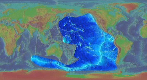
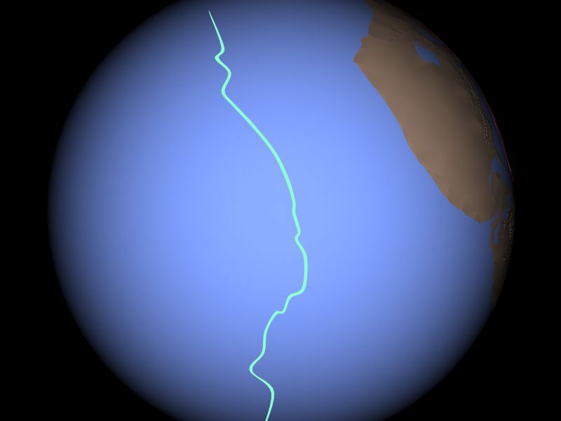
An earlier study of the effects of giant impacts concluded that "the primary shock wave of the canonical Moon-forming giant impact melted about 30-55% of the planet [Earth], depending on its initial temperature." "This melt is likely to be rapidly extruded onto the surface before it solidifies." In fact, continental crust covers 41% of Earth's surface. Previously, some researchers had erroneously proposed that such a collision would melt the whole planet.6 It is reasonable to propose that a sufficiently large impact would mix basalt crust with mantle to form continental crust. This is the Shock Dynamics position. On the other hand, making continental crust through plate interaction remains a problem for Plate Tectonics theory: "Our understanding of how continents grow and differentiate still remains somewhat obscure."1 "A fundamental problem in the formation of continental crust is that the majority of magmas erupted on earth are basaltic and yet the continents do not have a basaltic bulk composition."3 "The continental crust has an andesitic bulk composition, which cannot have been produced by the basaltic magmatism that dominates sites of present-day crustal growth."5 "Continental crust overlies continental lithosphere simply because it is made up of the lighter of the two types of 'surface seeking' [or floating] materials." "The origin of subcontinental lithosphere is not well understood. Downward freezing of asthenosphere... is not an acceptable explanation because this process would produce lithosphere with about the same composition as normal [oceanic] asthenosphere."2 "Although the process is complicated, [continental] crust formation boils down to the extraction of material of granitic composition from a source of basaltic composition."2 An early idea, and one that remains popular, is "that the continents form by accretion of island arcs of andesitic composition." Island arcs are lines of volcanos at subduction zones; the lava is andesitic. "This 'andesite model' of crustal growth appealed to uniformitarian sensibilities, in that processes we see occurring today could account for the formation of the continents. Subsequent investigations of continental crust and island arcs, however, have demonstrated the difficulties with this simple model. The andesite model of crust formation cannot account for the bulk-crust Cr and Ni contents (average andesites have abundances that are too low) nor its Th/U ratio. Furthermore, a large portion of the continents probably formed during [ancient] Archaean times and andesites are uncommon in Archaean volcanic sequences." Perhaps most problematic for the andesite model, however, is that intra-oceanic island arcs are estimated to have basaltic, rather than andesitic, bulk compositions." "Thus accretion of modern island arcs produces basaltic crustal additions and cannot account for the intermediate composition of post-Archaean crust."5 Experiments have shown that it is possible to produce andesite from material below the crust, peridotite, by adding high heat and water, "leading to generation of mantle-derived intermediate to silicic melts." Researchers believe these conditions may have existed during Archaean times.5 It should be noted that these conditions would also likely have been present when the planetesimal struck Earth, leading to the formation of the Moon. The mixture of mantle and oceanic crust is fundamental, yet is difficult to achieve by a slow series of actions that Plate Tectonics requires: "Continental crust consists of granitoid rocks that formed through a complex series of events, which includes partial melting of peridotite to form basalt, and reprocessing of basalt in a subduction environment."2 The "formation of continental crust generates large volumes of residue." For example, "the formation of 40 km-thick crust generates a 200 km-thick layer of mafic cumulate or restite."2 That is true for all continental crust, which covers 41% of Earth. This dense material is missing and must have fallen deep into the Earth. Yet if continental crust formation has been ongoing, as Plate Tectonics theory proposes, then this waste material should be just below continental crust at various places around the world. On the other hand, if it formed early into a protocontinent, as Shock Dynamics theory proposes, then all of it would have fallen away long ago. "'Delamination' of the lower crust has been suggested as a possible mechanism for the removal of the mafic residues of basalt differentiation." Researchers have "proposed that a mafic lower crust, if it is thickened and cooled sufficiently, will convert to a high-density mineral assemblage, leading to a gravitationally unstable configuration in which the lower crust can sink into the underlying lower-density mantle."3 "It appears that lithospheric thickening (such as occurs at sites of continental-scale collisions) is required to achieve delamination."5 However, "because subduction is a continuous process, the episodic pattern of crust formation ages is a strong argument against crustal growth at converging boundaries."1 Another version refers to "convective instabilities". "This process is distinct from delamination because the lower crust does not 'peel off', but rather forms 'blobs' that drip off the base of the crust."3 But another element is necessary. "Calculation of the instability times for a dense, lower crustal layer to sink into the mantle show that high temperatures (>700 degrees C, or >500 degrees C with an initial background strain rate) are required for this process to occur in ~10 million years. The high temperatures required... suggest that this process is restricted to [island] arcs, volcanic rifted margins, and continental regions that are either undergoing extension, are underlain by a mantle plume or have had part of the conductive upper mantle removed."3 "Although delamination... provides a means of explaining the non-basaltic composition of the crust, it is a difficult process to document." And "recognizing delamination in older regions remains a difficult proposition."5 1. Albarede, Francis. 1998. The growth of continental crust. Tectonophysics, Vol. 296, pp. 1-14. 2. Arndt, Nicholas T., Eric Lewin, Frances Albarede. 2002. Strange partners: formation and survival of continental crust and lithospheric mantle. in The Early Earth: Physical, Chemical and Biological Development. Fowler, C.M.R., C.J. Ebinger, C.J. Hawkesworth, editors. Geological Society, London, Special Publications, Vol. 199, pp. 91-103. 3. Jull, M., P.B. Kelemen. April 10, 2001. On the conditions for lower crustal convective instability. Journal of Geophysical Research, Vol. 106, No. B4, pp. 6423-6446. 4. Reese, C.C., C.P. Orth, V.S. Solomatov. 2011. Impact megadomes and the origin of the martian crustal dichotomy. Icarus, Vol. 213, pp. 433-442. 5. Rudnick, Roberta L. 7 December 1995. Making continental crust. Nature, Vol. 378, pp. 571-578. 6. Tonks, W. Brian, H. Jay Melosh. March 25, 1993. Magma Ocean Formation Due to Giant Impacts. Journal of Geophysical Research, Vol. 98, No. E3, pp. 5319-5333. The ridge that was there long before Highlighted below is seafloor that was not overrun by continents or crustal waves. A spreading ridge extends from the southern Indian Ocean (Mid-Indian or Southwest Indian Ridge) to the eastern Pacific (East Pacific Rise). As a "fast" spreading ridge, it looks smoother on this digital elevation map than other spreading ridges,
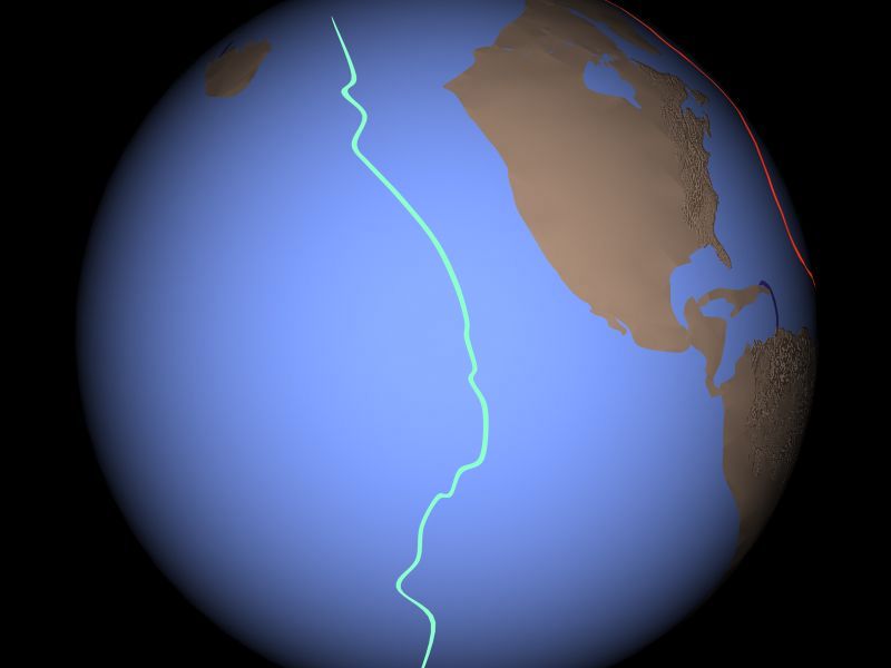
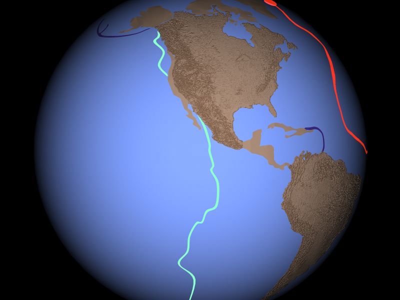
and appears to have been run over by North America.
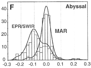
It may be a remnant of the collision that could have produced the Moon and the protocontinent. Evidence that the East Pacific Rise (EPR) and the Southwest Indian Ridge (SWIR) existed prior to the Mid-Atlantic Ridge (MAR) is found in their chemistry. Differences in the level of silicon enrichment, measured in comparison to magnesium (Mg/Si), are shown in the histogram below.
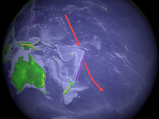
Samples of the ridge rock (abyssal peridotite) were tested. "Most samples on the MAR from drill cores are normally distributed about zero, whereas those dredged from the EPR and SWIR show consistently negative Mg/Si." "These chemical shifts are well known in peridotites from modern ocean basins as products of marine weathering and hydrothermal alteration." That indicates that the EPR/SWIR rocks are old and weathered compared to the MAR. Yet plate tectonics says that rocks at the center of all active ridges are young, and should be distributed about zero. The EPR is supposed to be spreading faster than the MAR, so it should show even less weathering! The hump in the EPR/SWIR histogram above zero is likely due to samples from the new part of the SWIR, formed during the Shock Dynamics event (see the shaded map above). Canil, Dante, Cin-Ty A. Lee. July 2009. Were deep cratonic mantle roots hydrated in Archean oceans? Geology, Vol. 37, No. 7, pp. 667-670. Another feature on the Pacific floor that appears to have been there earlier and then overrun is the Marshall-Gilbert Island chain to the north and the Louisville Ridge-Eltanin Fracture Zone to the south. They are on the left of the red arrows below. The crustal wave that ended as the Tonga Trench ran over this line.
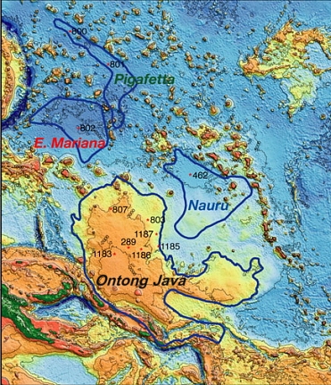
It is likely that the Ontong Java Plateau, a huge flood basalt feature, was in place prior to the event as well. The northern edge of the crustal wave guided around the southern side of the plateau as the wave rolled east. In the above picture, Ontong Java is the wispy white area to the left of the top arrow. It is outlined in the picture below.
A pair of researchers has even proposed that the Ontong Java Plateau was formed by a large impact. They find that "an object about 20 kilometers in diameter impacting... Pacific lithosphere and penetrating into the uppermost asthenosphere would have initiated massive decompression melting in the upper mantle, and may have resulted in emplacement of the greater Ontong Java Plateau", including the other provinces shown above. "Geophysical, geochemical, and geodynamic evidence from the [Ontong Java] province are difficult to reconcile with mantle plume models", the commonly accepted explanation for its origin. Ingle,
Stephanie, Millard F. Coffin. 2004. Impact origin for
the greater Ontong Java Plateau? Earth and Planetary
Science Letters, Vol. 218, pp. 123-134.
|