Hawaii, we thought we knew you
The classic Plate Tectonics story for Hawaii now appears to be mistaken. The Pacific plate did not suddenly change directions, and there is no deep, stationary plume. Other explanations fit the evidence better.
(This discussion is presented in the Plate Tectonics paradigm, referencing professional geologic journal papers. The Shock Dynamics perspective is described afterwards.)
Introduction
The
chemical makeup of magma extruded at the surface is not all the
same. Put simply, the recipes are Mid-Ocean Ridge Basalt (MORB)
and Ocean Island Basalt (OIB), with variations on these two. Attempts
to determine the sources of the different chemistries and why they
appeared where they did was a principal inspiration for the plume
theory. Earth was considered to have a number of distinct
layers in it down to the core, each having a particular chemistry
that was generally the same (homogeneous) throughout the layer.
Thermal plumes were conceived to transport material from deep
layers to the surface, and the Hawaiian plume became the main
example. There have long been challenges to the plume concept,
but these have intensified over the last 15 years as tomographic
and chemical data have improved. The rebels have the smaller
army in this battle, but they are energized. They offer new
interpretations of Earth's interior that change everything
we learned in school about Hawaii.
The original idea
In
1963 Wilson suggested that the Hawaiian Islands formed as the Pacific
plate moved over continuously upwelling hot mantle. In 1968
Christofferson conjectured that the Emperor-Hawaii elbow records
a change in direction of the Pacific plate over a fixed "hotspot".
In 1971 Morgan speculated that the heat source is a stationary
"plume" rising vertically through the deep mantle, and
this has been widely accepted.6
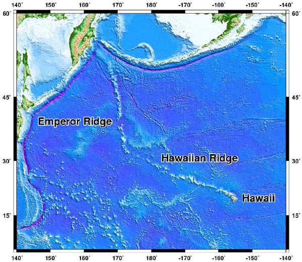
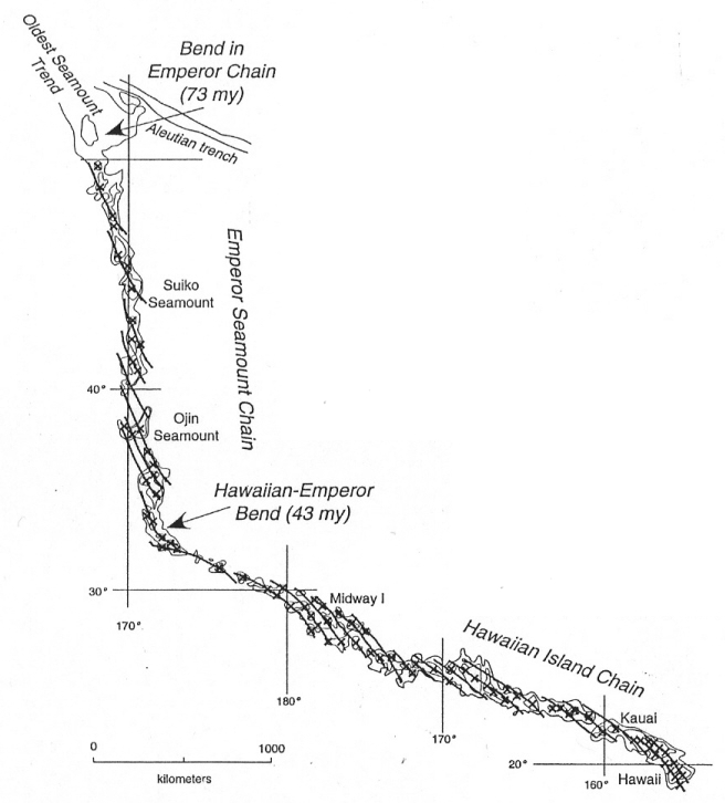
"The Hawaii-Emperor island and seamount chain is the most prominent morphologic feature on the seafloor, with a sharp 60° change in azimuth, called the Hawaii-Emperor bend (HEB). The HEB serves as a textbook example of the fixed hot spot hypothesis, in which changes in the azimuth of volcanic lineaments are explained by changes in plate motion, and the hot spots that created these volcanoes remain fixed beneath the moving tectonic plates."9 "Hawaii is thought to be the strongest currently active plume."13
Challenging the
original idea
"Simple tests falsify conjecture that
the...Emperor-Hawaii system formed above a stationary plume. As
this is the only testable purported plume, global speculation favoring
fixed plumes falls with it."6
1) Pacific plate motion
- no rapid change in direction
The
concept requires "an enormous reorganization of Pacific Ocean
plates 45 million years ago."6
This is not found anywhere "along the northeast, east,
or south sides of the Pacific plate," where crust of that age
is preserved.6
"The Pacific-Antarctic Ridge is the key link... tying
the relative motion of the oceanic plates of the Pacific basin to
the rest of the world."2
A survey of the Pitman Fracture Zone along this ridge was
carried out in 1992. The authors concluded that "predictions
of the track of the Hawaiian hot spot based on global reconstructions
fail, once again, to predict a large bend around 43 million years
ago."2
Next, "the Gilbert Ridge and Tokelau Seamounts are the
only seamount trails in the Pacific Ocean with a sharp 60° bend,
similar to the HEB." "The Louisville seamount trail
is not useful... because it shows only a very broad curvature at
its bend." Their study found that the Gilbert Ridge bend
formed around 67 million years ago, while the Tokelau bend formed
about 57 million years ago. They should have formed at the
same time as the HEB, around 47 million years ago, "if they
were formed by stationary hot spots, and assuming Pacific plate
motion only." "Such asynchronous bends cannot be
reconciled with the stationary hot spot paradigm."9
In addition, "improved mapping of marine magnetic anomalies
in the Pacific has failed to define the directional change at 43
million years ago." "There was also a general lack
of circum-Pacific tectonic events documented for this time. Recent
age data suggest a slightly older age for the bend, about 47 million
years ago, but this revised timing still does not correspond to
an episode of profound plate motion change recorded within the Pacific
basin or on its margins."15
"The textbook explanation for intraplate volcanism by
fixed hot spots is either entirely wrong or insufficient to explain
these phenomena."9
The most recent study of volcanoes of the central and southern
Emperor chain claims that the Hawaii-Emperor Bend started at 50
million years ago.12
This is still far off of the 57 and 67 million years ago that
are designated for the Gilbert Ridge and Tokelau Seamounts, and
does not lessen the misfit between the predicted track of the Hawaiian
hotspot, using magnetic anomalies at the Pitman Fracture Zone, and
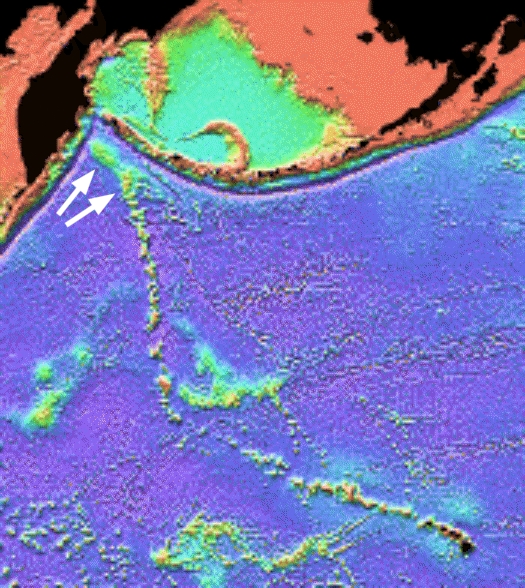
the actual island chain (below).
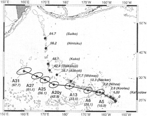
Predicted
hotspot track (circles) using Indo-Atlantic hotspot reference frame.2
2) Segments en
echelon - volcanoes not in one line
Instead of a straight line of volcanic islands, volcanic
ridges are oriented en echelon.7
3) Plume swell
(bulge) - not all there
A rising plume that reaches the lithosphere "would
be expected to produce an uplift of the lithosphere which should
be easily testable. Topographic swells such as those around
the Hawaiian islands hence became evidence of the existence of plumes"
As it turns out, "the size of the swell does not decline
along the Hawaiian chain, and there is no corresponding swell associated
with the Emperor chain."13
4) Plume heat -
missing
"Unfortunately
for the hotspot model, measurements along the axis of the Hawaiian
swell suggested an increase in heatflow with distance away from
the supposed site of the plume." Instead of a bulge,
the swell may "merely represent a thick section of basalt".13
"The concept of a Hawaiian plume is incompatible with
detailed surface-wave tomography that shows Hawaii, and other purported
hotspot swells southwest of it, to sit atop cool high-velocity mantle,
not hot low-velocity mantle as required by plume conjecture. No
plume-predicted thermal anomaly exists."6
5) Basalt chemistry - lots of variation
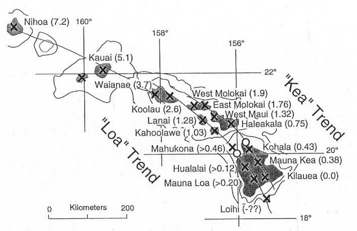
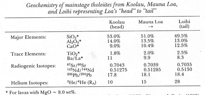
"The volcanoes along the Hawaiian Islands align along two distinct geographic segments (the 'Loa' and 'Kea' trends). Geochemical studies of the lavas that make up the Hawaiian Island volcanoes... point to the puzzling feature that two mature volcanoes situated only 40 km apart (Mauna Loa and Kilauea) are remarkably dissimilar in their geochemistry. In fact, geochemical variations... along the Loa trend show gradational changes with decreasing volcano age [see below], while the... volcanoes in the Kea trend are chemically distinct from adjacent volcanoes in the Loa trend."7
6) Hotspot stability
- much motion
"It
has long been known that purported hotspots move relative to one
another."6
"Comparison of an updated inventory of Pacific and non-Pacific
paleomagnetic data... indicates that missing plate boundaries and
other errors in the plate circuit play a relatively small role in
the" relative movement. "Motions between East and
West Antarctica can account for little more than about 20% of the
apparent motion between the Hawaiian-Emperor hotspot and the Indo-Atlantic
hotspots. The residual offset between the predicted and actual
hotspot position cannot be explained by reconstruction uncertainties
of the magnitude usually discussed." "We conclude
that most of the apparent motion between the Hawaiian-Emperor and
Indo-Atlantic hotspots is real."5
Also, "global plate circuits suggest large relative motions
between Hawaii and hotspots in the Atlantic and Indian Oceans.15
Relative motions have been calculated to be "as rapid
as 8 cm per year, faster than most relative motions between plates."6
Plume theory seems infinitely flexible. Researchers have proposed putting plumes in motion to solve the problem. Using paleomagnetic and radiometric age data, one group found that "the Emperor Seamount trend was principally formed by the rapid motion (over 4 cm per year) of the Hawaiian hotspot plume."15
Plumes are considered to advance in stages: first, the plume head and tail rise together. Then the head flattens and is assimilated, leaving only the tail. Finally, the tail is distorted by mantle flow, and may split into separate, winding segments. Melt zones "under hotspots usually do not show a straight pillar shape, but exhibit winding images, suggesting that plumes are not fixed in the mantle but can be deflected due to the influence of mantle flow."18 Complicating the matter, "the distribution of seamounts in time and space... indicate that either the Pacific plate has undergone numerous short-term velocity changes or the path of the upwelling plume has been affected in some way."7 One researcher proposed that hotspot motion southward may be due to deep mantle flow, but upper mantle convection cell return flow may be stringing out the top of the plume in the opposite direction.3 Another proposed that individual "plumelets" rise from a single deep melt zone, each plumelet forming a seamount segment.7 In the end he wondered why the supposed change in Pacific plate motion had so little effect on underlying mantle flow, and why "the generation of a new subduction zone (such as along the Tonga-Kermadec trench at about 45 million years ago) and subsequent intrusion of slab material exerted no observable impact on flow in the underlying mantle.7
7) Tomography (like a seismic MRI) - conflicting images
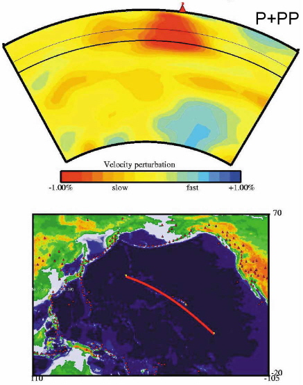
"Hawaii should have the most readily resolvable conduit [tail] as it is situated away from ridge systems and is supposedly the strongest plume." Two studies in 1998 "searched for low-velocity anomalies [melt zones] in the lower mantle beneath the hotspot, but found no low-velocity anomaly which correlated with the surface expression of volcanism." So both invoked plume deflection to resolve the issue. But while one "suggested the conduit to lie to the southeast of Hawaii," the other "claimed a double conduit to the northwest of Hawaii."13 Similarly, the author of a 2004 tomographic study believes his cross-section shows the prominent melt zone beneath Hawaii connected by a thin melt zone to a moderate melt zone offset to the north and down to the core-mantle boundary (below 2700 km). However, his regional tomographic map shows the prominent melt zone thinning considerably below the transition zone (660 km), reappearing offset to the west at 1100 km depth, and disappearing below 1820 km. So the plume would be deflected by mantle flow to the south or to the east.18
Tomography based on the travel-time of seismic waves has some inherent difficulties. "Seismic ray coverage is highly variable, and different types of rays are used to interrogate different depths." Tomography can show a false picture if the mantle is assumed to be uniform and it is not. Shallow heterogeneities (areas of varying density) and anisotropy (crystal alignment) can smear tomographic images when the mantle is assumed to be uniform, and most models do. Since most of the world's earthquakes occur in slabs, and many seismic stations are in their vicinity, the opportunity exists to smear this shallow anisotropy into an image of a deep slab. "Normal tomographic [images] cannot cancel out slab anisotropy, particularly in the deep mantle where seismic ray coverage is poor." Tomography shows that "in current subduction zones, descending slabs flatten out between 500 and 800 km." The supposed slabs in the deep mantle are separated, and up to 1500 km from expected locations.1
Return of an old
idea - lithosphere crack
"The lithosphere crack model
[is] the main alternative to the mantle plume model for age-progressive
magma emplacement along the Hawaiian-Emperor volcano chain".16
Calculations done in a 2007 study found the "incremental
stress field has the form necessary to maintain and propagate a
tensile crack... and is thus consistent with the crack model for
the Hawaiian volcano chain."16
In this model, "the cause of the Hawaiian-Emperor Bend
may have been a rapid change in the thermoelastic stress field associated
with the disappearance of ridge segments"16
at plate boundaries.
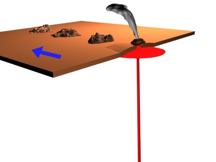
"The obvious alternative" to plumes forming seamount chains is "extension that permits rise of partial melt from the asthenosphere" [between the mantle and crust]. Thus the en echelon segments in seamount chains are "extensional fissures", so that extension controls the propagation of the chain.6 "The starting point for the construction of any counter-model has to be an acceptance of the evidence for amphibole and phlogopite in the source of OIB." "Intraplate volcanism results predominantly from compositional, not" heat differences. "The low melting point of such minerals would make them susceptible to shear melting to generate intraplate tracks." These have been called "wetspots" as opposed to "hotspots".13 "The Hawaiian chain sits on a buoyant pad of mantle rich in magnesian olivine, and magmas must be rising in fissures, not broad plumes." "Volcanoes will form wherever this potential melt can be tapped: the problem is access to the surface, and there is no... need for unique heat sources, nor any geochemical need for deep sources of components of melts. Volcanoes are products of" "extension" and "propagating cracks".6
"The crack model... was suggested for the Hawaiian volcanic chain as far back as 1849."4 In 1973, intraplate volcanism, including Hawaii, was proposed to be caused by lithospheric stress, with intermittent eruptions due to the shallowness of the source regions. "Cessation of volcanism in the absence of changes in the stress field can be explained by exhaustion of low-melting point minerals." On the other hand, opening a melt pocket would give the impression of the arrival of plume material.14 In 1975, two authors wrote "we conclude that the trends and age correlations of volcanic loci in the Pacific accurately track and identify the evolution of states of stress in the Pacific lithosphere with time." There was "magma injection from a source in the asthenosphere into a rigid Pacific plate subjected to rotations of principal stress directions."8 A 1987 study evaluated two other hypotheses, small-scale convection and compressive buckling, and decided in favor of tension (pull apart) cracks in the Pacific plate. The shape and positions "of the en-echelon ridges suggest that they result from filling of tensional cracks in the lithosphere." "Experimental and theoretical studies... show that plastic yielding occurs... oriented 55-60° from the direction of tensile stress." "Extension opens the cracks and shear produces the en-echelon pattern." Pacific plate earthquakes "show plate-wide tension oriented NNE." However, their "data do not indicate the source of the tensile stress", and they speculated on several possibilities.17
If one or more chains of linear volcanic ridges are shown to be formed by extension rather than by fixed hotspots as previously proposed, then the application of the fixed-hotspot model to other linear volcanic chains may be questioned.11 The authors of the Gilbert Ridge/Tokelau Seamounts study mentioned above proposed "that the southwestern Pacific plate experienced two such short-term extensional phases."9
"The crack model is appealing because several first-order features of the Hawaiian and Emperor chains that are inconsistent with the plume model or require surprising coincidences may be consistent with the crack model. These include the inception of the Emperor chain on a ridge, the lack of a 'plume head' large igneous province, the ~60° change in propagation direction that occurred around 47 million years ago, the rapid southward migration of the Emperor hotspot prior to this, and the lack of the heatflow anomaly expected for a plume."16
Shock Dynamics
interpretation
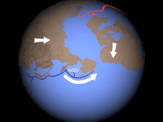
In the Shock Dynamics model, the starting
point for the Emperor-Hawaii chain is next to the point where Alaska
separates from Kamchatka and Siberia, so it is most likely connected
with this move.
Notice that the first two eruptions, Meiji and Detroit seamounts, are the largest plateaus in the entire chain. The first is also oriented at a different angle from the rest of the Emperor chain.
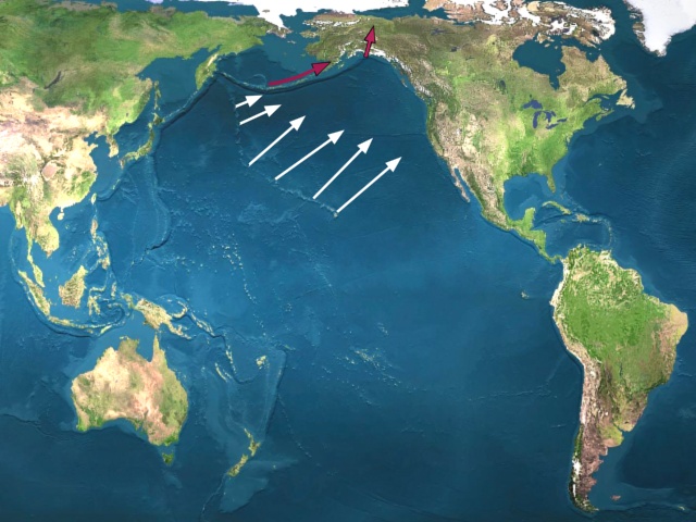
Assuming the tensional stress-crack alternative to the plume model described above is correct, it becomes a matter of determining what pulled on the crust. Clearly it must be the motion of Alaska (red arrows, below). White arrows indicate the orientation of fissures along the chain.
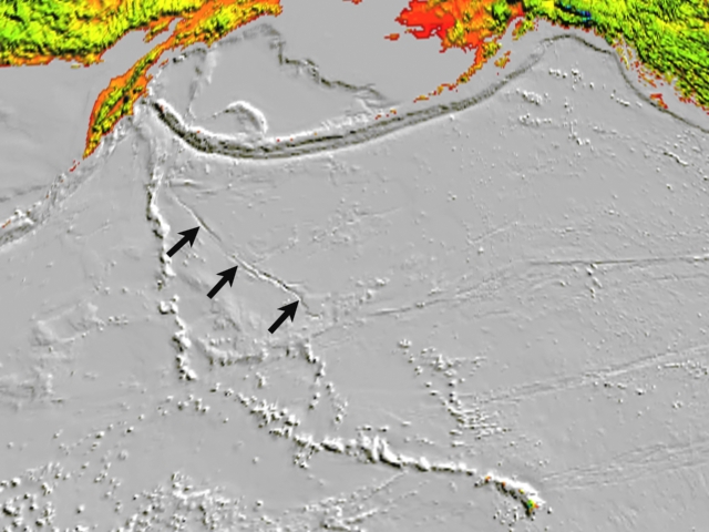
A long rift or fault, often overlooked, branches off of the Emperor Seamount chain. It also indicates pull-apart stretching towards Alaska.
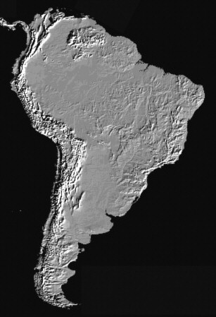
The sudden bend is caused by what I call the Great Brake, when South America's leading edge stopped sliding west at today's Peru/northern Chile coast, causing severe compressive mountain building. With friction re-established there, South America transferred its mass and westward momentum to the lithosphere, which had a sudden braking effect on the entire global lithosphere.
Gravitational interaction between the Earth and Moon generate a tidal force that provides a constant westward pull on the lithosphere.
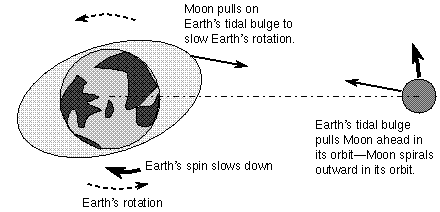
The approximately "2 - 3 degree tidal lag angle between the tidal bulge and the gravitational alignment between the Earth and Moon determines a permanent torque toward the "west", opposite to the eastward rotation of the planet. This torque is considered responsible for the secular deceleration of the Earth, and acts directly on the lithosphere." "To conserve the angular momentum of the system, the Earth's deceleration is mostly compensated by the enlarging of the Moon's orbit, at a rate of 38.2 + 0.7 mm/yr."19
From:
Zaccagnino, Davide, Francesco Vespe, Carlo Doglioni. June
2020. Tidal modulation of plate motions.
Earth-Science Reviews, Vol. 205,
103179. DOI:10.1016/j.earscirev.2020.103179
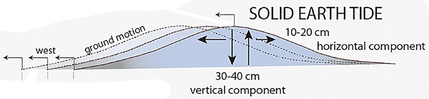
"The solid Earth tides have a well-known vertical oscillation of 300 - 400 mm/12 h 25', but they also have a relevant 150 - 200 mm/12 h 25' horizontal swinging [i.e. stress loading]. Under a permanent torque, this oscillation may induce a tiny strain in the upper asthenosphere, say 0.1 -0.2 mm. The cumulative effect of this small horizontal motion... may well reach several centimeters (7 - 14) per year". "The advantage of this mechanism is to act contemporaneously all over the lithosphere."19
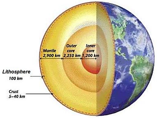
Earth has many layers, and the inner core, mantle, and lithosphere/crust rotate on slightly different axes, due to forces applied in the past. They can do that because the outer core and asthenosphere act as lubricating layers.
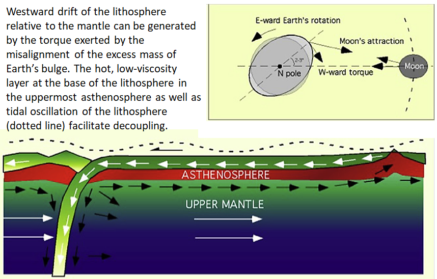
From:
Doglioni, C., & Panza, G. 2015. Polarized Plate Tectonics. In
R. Dmowska (Ed.) Advances in Geophysics, pp. 1167. ISBN: 9780128022481
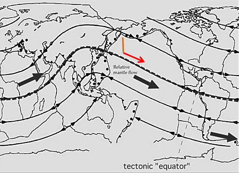
The path of mantle flow applied to a flat map of Earth's surface is shown below, with the Hawaiian chain as a red arrow. Propagation of a crack in basalt, particularly 7 km-thick oceanic crust, though very fast would be a fraction of the Rayleigh wave speed of 6700 mph. The Great Brake lasted about 2 hours. Earth's rotational speed at the Equator is a little over 1000 mph, decreasing towards the poles. Since the Hawaiian chain is about 1500 miles long, 21 degrees north, and parallel to mantle flow, the combination of drag of Alaska north, applying tension to the Pacific crust, and the Great Brake could explain the origin of the enigmatic Emperor/Hawaiian island chain.
* * * * * * *
- Anderson, Don L. 2002. The Case for Irreversible Chemical Stratification of the Mantle. International Geology Review, Vol. 44, pp. 97-116.
- Cande, Steven C., Carol A. Raymond, Joann Stock, William F. Haxby. 10 November 1995. Geophysics of the Pitman Fracture Zone and Pacific-Antarctic Plate Motions During the Cenozoic. Science, Vol. 270, pp. 947-953.
- Cox, R. T. 1999. Hawaiian volcanic propagation and Hawaiian swell asymmetry: evidence of northwestward flow of the deep upper mantle. Tectonophysics, Vol. 310, pp. 69-79.
- Dana, J.D. 1849. U.S. Exploring Expedition during the years 1838-1842 under the command of Charles Wilkes, U.S.N. Geology, Vol. 10, pp. 307-336.
- DiVenere, Vic, Dennis V. Kent. 1999. Are the Pacific and Indo-Atlantic hotspots fixed? Testing the plate circuit through Antarctica. Earth and Planetary Science Letters, Vol. 170, pp. 105-117.
- Hamilton, Warren B. 2002. The Closed Upper-Mantle Circulation of Plate Tectonics. in Plate Boundary Zones, Geodynamics Series Volume 30, eds. Seth Stein & Jeffrey T. Freymueller, pp. 359-410.
- Ihinger, Phillip D. November 1995. Mantle flow beneath the Pacific plate: evidence from seamount segments in the Hawaiian-Emperor chain. American Journal of Science, Vol. 295, pp. 1035-1057.
- Jackson, Everett D., Herbert R. Shaw. May 10, 1975. Stress Fields in Central Portions of the Pacific Plate: Delineated in Time by Linear Volcanic Chains. Journal of Geophysical Research, Vol. 80, No. 14, pp. 1861-1874.
- Koppers, Anthony A. P., Hubert Staudigel. 11 February 2005. Asynchronous Bends in Pacific Seamount Trails: A Case for Extensional Volcanism? Science, Vol. 307, pp. 904-907.
- Meibom, Anders, Don L. Anderson. 2003. The statistical upper mantle assemblage. Earth and Planetary Science Letters, Vol. 217, pp. 123-139.
- Sandwell, David T., Edward L. Winterer, Jacqueline Mammerickx, Robert A. Duncan, Mary Ann Lynch, Daniel A. Levitt, Catherine L. Johnson. August 10, 1995. Evidence for diffuse extension of the Pacific plate from Pukapuka ridges and cross-grain gravity lineations. Journal of Geophysical Research, Vol. 100, No. B8, pp. 15,087-15,099.
- Sharp, Warren D., David A. Clague. 1 September 2006. 50-Ma Initiation of Hawaiian-Emperor Bend Records Major Change in Pacific Plate Motion. Science, Vol. 313, pp. 1281-1284.
- Smith, Alan D., Charles Lewis. 1999. The planet beyond the plume hypothesis. Earth-Science Reviews, Vol. 48, pp. 135-182.
- Smith, Alan D., Charles Lewis. 1999. Differential rotation of lithosphere and mantle and the driving forces of plate tectonics. Geodynamics, Vol. 28, pp. 97-116.
- Tarduno, John A., Robert A. Duncan, David W. Scholl, Rory D. Cottrell, Bernhard Steinberger, et al. 22 August 2003. The Emperor Seamounts: Southward Motion of the Hawaiian Hotspot Plume in Earth's Mantle. Science, Vol. 301, pp. 1064-1069.
- Stuart, William D., Gillian R. Foulger, Michael Barall. 2007. Propagation of the Hawaiian-Emperor volcano chain by Pacific plate cooling stress. in Geological Society of America Special Paper 430, eds. G.R. Foulger and D.M. Jurdy, pp. 497-506.
- Winterer, E. L., D. T. Sandwell. 8 October 1987. Evidence from en-echelon cross-grain ridges for tensional cracks in the Pacific plate. Nature, Vol. 329, pp. 534-537.
- Zhao, Dapeng. 2004. Global tomographic images of mantle plumes and subducting slabs: insight into deep Earth dynamics. Physics of the Earth and Planetary Interiors, Vol. 146, pp. 3-34.
- Riguzzi, Federica, Giuliano Panza, Peter Varga, Carlo Doglioni. 2010. Can Earth's rotation and tidal despinning drive plate tectonics? Tectonophysics, Vol. 484, pp. 60-73.
John Michael Fischer, 2006, 2024
www.newgeology.us
![]()