 |
Asia
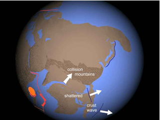
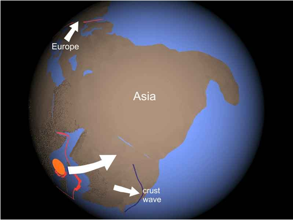
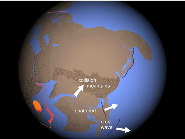
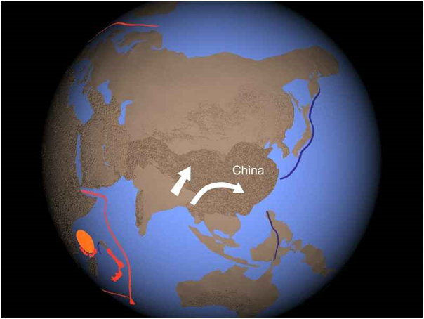
As the block consisting of Australia, India, and Southeast Asia slammed into Asia, Europe was being pulled away by North America. The crustal wave, shown here in blue, is actually beneath the continents. The collision with Asia shattered the block and built mountains. The crustal wave split in two. The collision sent Australia careening eastward. As Asia moved north, more mountains grew and Japan was thrown outward, forming a trench. Momentum drove India and Southeast Asia deeper into Asia, causing China to be pushed out. Asia pivoted counterclockwise, driving Europe down and raising the Ural Mountains.
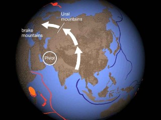
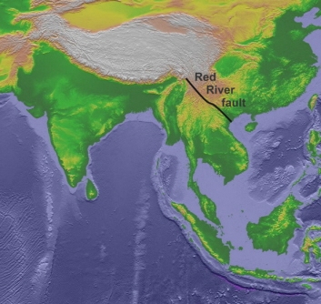
This is the topography of the pivot area.
Southeast
Asia collided with Asia along the Red River fault zone, which "is
the major geological discontinuity that separates South China from
Indochina." As India drove into Asia, China was pushed
to the east, sliding along the Red River fault zone. "It is fair to say that this zone is
to continental strike-slip faults what the Himalayas are to mountain
ranges."
Leloup,
Philippe Herve, Robin Lacassin, Paul Tapponnier, Urs Shaerer, Zhong
Dalai, Liu Xiaohan, Zhang Liangshang, Ji Shaocheng, Phan Trong Trinh.
1995. The Ailao Shan-Red River shear zone (Yunnan, China), Tertiary
transform boundary of Indochina. Tectonophysics, Vol. 251, pp. 3-84.
The
formation of the Ural Mountains "involved large-scale (up to
100-150 km) westward overthrusting . . . This gave rise to the
orogenic belt."
Kostiuchenko, S.L., A.V. Egorkin,
L.N. Solodilov. 1998. The
Lithospheric Structure beneath the Urals: Evidence from Multiwave
Deep Seismic Sounding. Geotectonics, Vol. 32, No. 4, pp. 253-266.
South Asia is the most spectacular example in the world of continental collision and mountain building by collision. Yet researchers are still wrestling with what happened there in the context of plate tectonics. "Convergence between the Indian and Eurasian plates is estimated to be at least 1000-1400 km or as much as 2000-3000 km. How this shortening has been accommodated is still not well known."1 One study found that continents riding on the 'plates' of plate tectonics are not very solid. Using a precision radar-satellite method to measure deformation to within a few millimeters, researchers had these comments:
"Satellite measurements
of the Tibetan Plateau suggest that when continents go head-to-head
in mountain building, they can behave more like unbaked pizzas."
"The latest evidence for squishy continents comes from
a satellite-borne technique called interferometric synthetic
aperture radar (InSAR)." "The plateau, the researchers
conclude, is yielding and deforming like so much putty." "
'In my view, there's no question,' says [Peter] Molnar [of Colorado
U. - Boulder]. 'Continental tectonics is not plate tectonics.'
" "The upper 100 kilometers of rock 'really looks
like a fluid' in GPS maps of surface motion, says [Roger] Bilham [of Colorado U. - Boulder]. 'It's as if India were colliding
with a water bed.' "2
1.
Li, Chang, Robert D. van der Hilst, Anne S. Meltzer, E. Robert
Engdahl. 2008. Subduction of the Indian lithosphere beneath the
Tibetan Plateau and Burma. Earth and Planetary Science Letters,
Vol. 274, pp. 157-168.
2. Kerr, Richard A. 9 July
2004. Hammered
by India, Puttylike Tibet Shows Limits of Plate Tectonics. Science, Vol. 305, p. 161,
Wright, Tim J.,
Barry Parsons, Philip C. England, Eric J. Fielding. 9 July 2004.
InSAR Observations
of Low Slip Rates on the Major Faults of Western Tibet.
Science, Vol. 305, pp. 236-239.
The
collision stopped long ago, but the Himalayas continue to slowly
rise due to isostasy (the crust floats to a level that
matches its thickness and density). Because the collision
thickened the crust, it is rising to a new equilibrium. Uplift
is 4 to 6 mm per year for the Greater Himalaya, and 2 to 3
mm per year for the Lesser Himalaya.
Jackson,
Michael, Roger Bilham. July 10 1994. Constraints on Himalayan deformation
inferred from vertical velocity fields in Nepal and Tibet. Journal of
Geophysical Research, Vol. 99, No. B7, pp. 13,897 13,912.
Researchers
using tomography to look deep below the surface found "that
underthrusting of Indian lithosphere far beneath the Tibetan plateau
is restricted to the western part of the collision zone." Their
"observations argue against significant underthrusting of the
Indian lithospheric mantle beneath the eastern plateau", going
"no further than the Himalayan Block" in the foothills
of southern Tibet.
Li,
Chang, Robert D. van der Hilst, Anne S. Meltzer, E. Robert Engdahl.
2008. Subduction of the Indian lithosphere beneath the Tibetan Plateau
and Burma. Earth and Planetary Science Letters, Vol. 274, pp. 157-168.
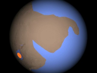
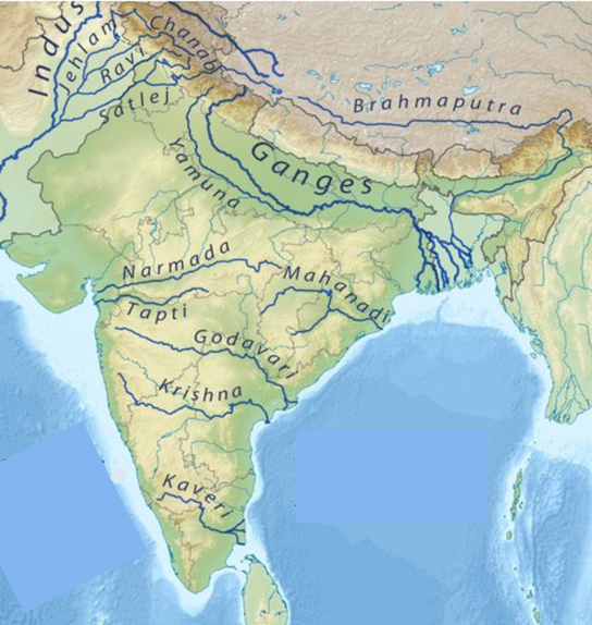
After the block consisting of Australia, India, and Southeast Asia slammed into Asia, Australia separated and rolled away. Extremely thick sediment in the Bay of Bengal off India's east coast was left behind. Plate Tectonics has no explanation for this sediment blanket.
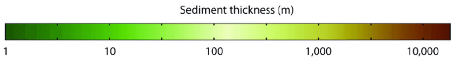
From:
Lipp, Julius. 2008. Intact membrane lipids as tracers for microbial life in the
marine deep biosphere.
Doctoral dissertation in natural science, University of
Bremen. http://elib.suub.uni-bremen.de/diss/docs/00011010.pdf.
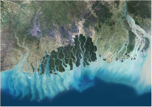
The vast sediment blanket is not river outflow. Although there is a major delta on the Bangladesh coast, it is narrow, as you can see in the close-up satellite photo.
Comparing Plate Tectonics to Shock Dynamics
The India challenge
In Plate Tectonics theory, India collided with Asia at a speed of 7 to 10 centimeters (2.76 to 4 inches) per year while attached to a lithospheric plate. Obviously, such a collision would produce no momentum, unlike a high-speed collision such as a bat hitting a ball so hard it breaks, forcing the end of the bat forward:

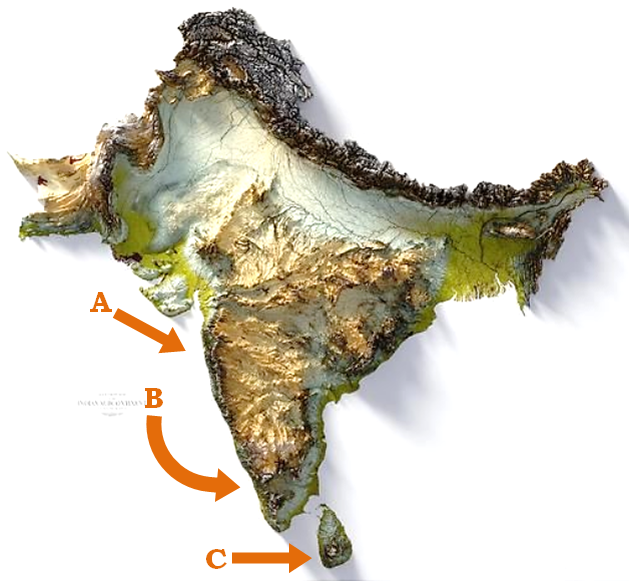
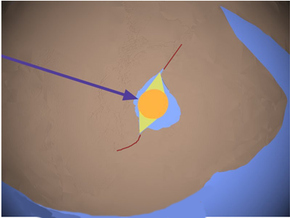
In Shock Dynamics theory, India slid on top of the underlying lithosphere, colliding with Asia at high speed (roughly 300 miles per hour) while moving northeast. You can see how momentum carried (B) southern India and (C) Sri Lanka to the east, ripping open (A) the Gulfs of Kachchh and Khambhat:
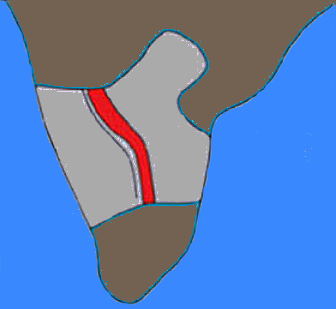
The stress of bending made the Closepet batholith (red) and the Dharwar craton (light gray). This craton "dates" to ancient Archean time, but it is really an example of how stress melting of continental crust produces "older" ratios of parent/daughter radioisotope elements through fractionation (see Cratons). The Closepet batholith formed where magma rose as the west and east sides of the crust slid against each other along a shear zone.
This is what developed globally from the protocontinent to the giant impact to the aftermath:
The
side blowouts from the oblique impact initiated a split in the protocontinent
Showing
their original positions
Asia
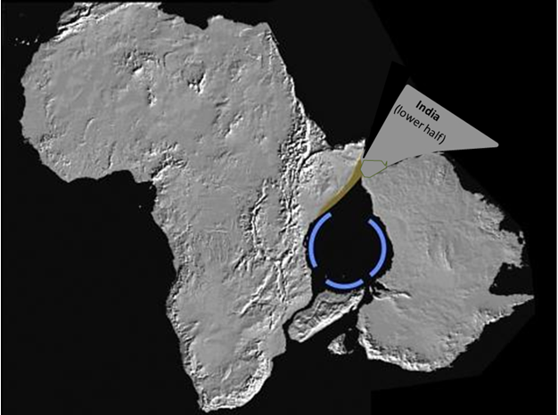
absorbed roughly 700 miles of the collision, with increasing resistance

Showing
India's final position
The Sri Lanka challenge
|
|
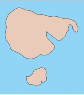
Sri Lanka is a 25,332 square-mile island off southern India. |
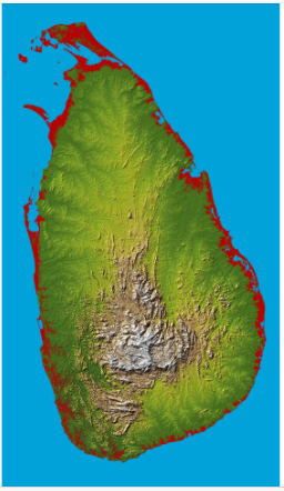
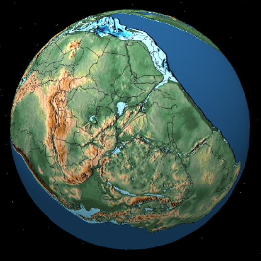
Plate Tectonics theory says there was a single southern landmass called Gondwanaland, and that 200 million years ago Sri Lanka was packed in next to India, Antarctica, and Africa.
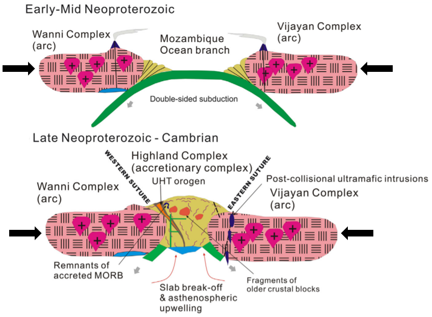
This is a diagram of the Plate Tectonics story for the formation of Sri Lanka. It is a side-view cross-section showing two of its complexes pushed together and piling up in the middle. The upper image is supposed to have happened 924 - 966 million years ago, continuing from 617 - 770 million years ago. The lower image is supposed to have happened 550 million years ago with the final assembly of Gondwana. - He, Xiao-Fang, M. Santosh, T. Tsunogae, Sanjeewa P.K. Malaviarachchi, P.L. Dharmapriya. 2016. Neoproterozoic arc accretion along the 'eastern suture' in Sri Lanka during Gondwana assembly. Precambrian Research, Vol. 279, pp. 57-80. DOI: 10.1016/j.precamres.2016.04.006
Then Gondwana is supposed to have broken apart. Below is an illustration of Plate Tectonics' rifting along the African coast at 170 million years ago. Sri Lanka stayed with India all the way to the present. From: Katupotha, Jinadasa. December 31 2019. Wandering of Sri Lanka from Precambrian to Recent. Wildlanka, Journal of the Department of Wildlife Conservation, Sri Lanka, Vol. 8, No. 1, pp. 209-232.
"Sri Lanka experiences few earthquakes or major volcanic events because it rides on the center of the plate." From: http://countrystudies.us/sri-lanka/31.htm
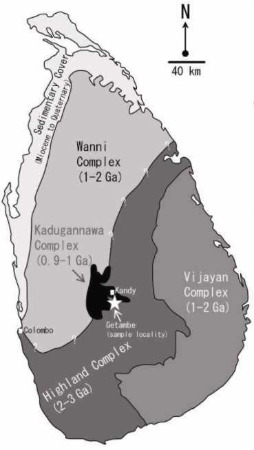
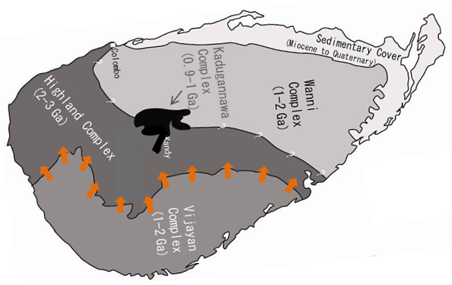
What is interesting is that over 90% of Sri Lanka is underlain by Precambrian high-grade metamorphic rocks, in three main divisions: the Highland Complex, Vijayan Complex, and Wanni Complex, based on the lithology, metamorphic grades and isotope characteristics. From: Chandrajith R. 2020. Geology and Geomorphology. In: Mapa R. (eds) The Soils of Sri Lanka. World Soils Book Series. Springer, Cham. DOI:10.1007/978-3-030-44144-9_3
For the granulites (high-grade metamorphic rocks) of the Highland Complex, "Thermobarometric calculations yield an estimated Pressure-Temperature of at least 1100 degrees Centigrade and 12,000 bar for the near-peak metamorphism." (1.013 bar equals the average atmospheric pressure at sea level on Earth.) That is "ultrahigh temperature". Sajeev, K., Y. Osanai. 2004. Ultrahigh-temperature Metamorphism (1150 degrees C, 12 kbar) and Multistage Evolution of Mg-, Al-rich Granulites from the Central Highland Complex, Sri Lanka. Journal of Petrology, Vol. 45, No. 9, pp. 1821-1844. DOI: 10.1093/petrology/egh035
" it has become widely accepted that a single ~610 - 456 Ma metamorphic event is represented in all these terranes " Ng, Samuel Wai-Pan, Martin J. Whitehouse, Tammy Pui-Yuk Tam, Pathmakumara Jayasingha, Jean Ping-Mei Wong, Steven W. Denyszyn, Joyce Sum-Yee Yiu, Su-Chin Chang. June 2017. Ca. 820640 Ma SIMS U-Pb age signal in the peripheral Vijayan Complex, Sri Lanka: Identifying magmatic pulses in the assembly of Gondwana. Precambrian Research, Vol. 294, pp. 244-256. DOI:10.1016/j.precamres.2017.03.013
In the Plate Tectonics scenario, "The metamorphic rock surface was created by the transformation of ancient sediments under intense heat and pressure during mountain-building processes." From: http://countrystudies.us/sri-lanka/31.htm
The problem is that nothing in the Plate Tectonics scenario makes this a high-grade metamorphic event for all the complexes that make up Sri Lanka. It is the same subduction-collision mechanism Plate Tectonics uses to produce compressional mountains around the world without high-grade metamorphism. The 2016 paper with the above diagram of the formation of Sri Lanka mentions high-grade metamorphism many times without explanation for extreme temperature and pressure aside from parts of the Highland Complex.
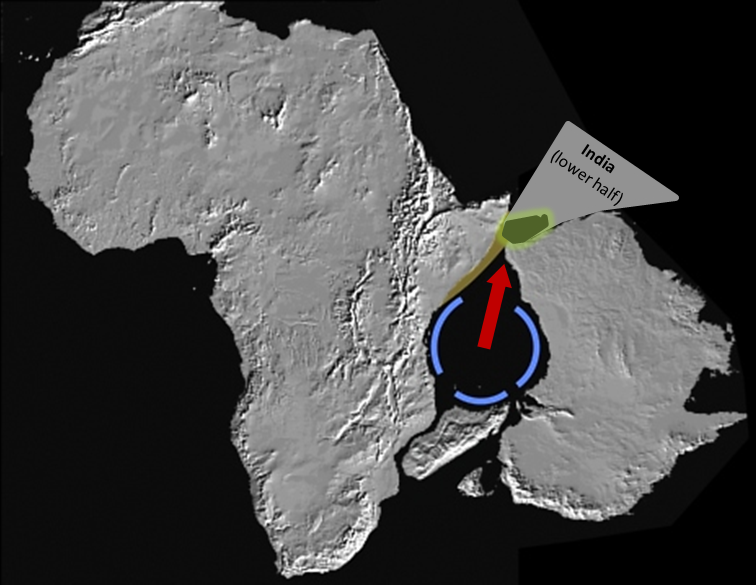
Shock Dynamics sees Sri Lanka differently. It was attached to India and next to the giant meteorite impact craters north-side blowout, where it was exposed to high heat and pressure. Sri Lanka is in green below. Notice the orientation.
Seismic tomography shows Sri Lanka's crust is of average thickness, unchanging across the several complexes. Researchers offer an interesting explanation for a westward-dipping "interface" (thin shear zone) in the Highland Complex: that the Vijayan Complex was thrust into the Highland Complex (orange arrows below). - Dreiling, J., F. Tilmann, X. Yuan, C. Haberland, S. W. M. Seneviratne. 2020. Crustal structure of Sri Lanka derived from joint inversion of surface wave dispersion and receiver functions using a Bayesian approach. Journal of Geophysical Research: Solid Earth, Vol. 125, e2019JB018688. DOI:10.1029/2019JB018688
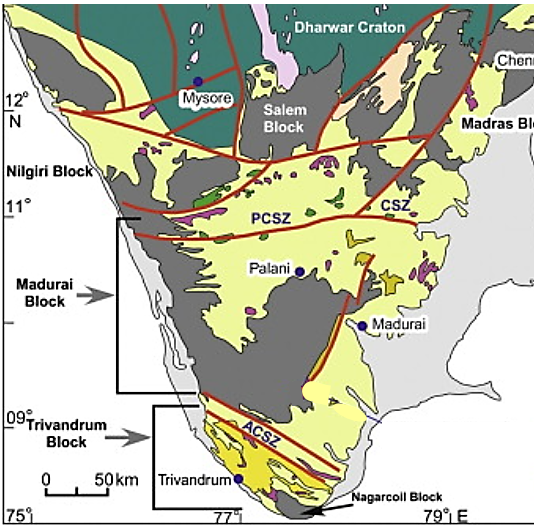
The impact blast passed through Sri Lanka into southern India, forming the Achankovil Shear Zone (ACSZ on the map below). Major shear zones in India are red lines here. The shear zones in northern India are from its subsequent collision with Asia.
The conventional narrative and dates do not align with the Shock Dynamics interpretation. But the rest of the evidence has a remarkable fit, and a plausible explanation that the Plate Tectonics version lacks.
![]()