 |
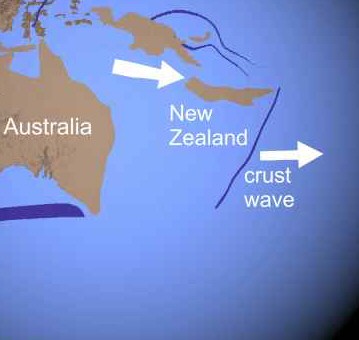
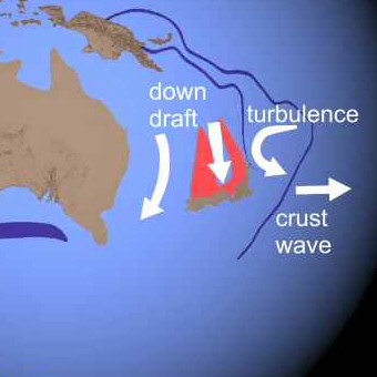
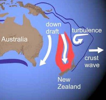
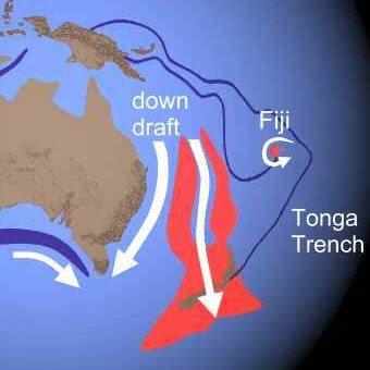
Southeast Asia - New Zealand
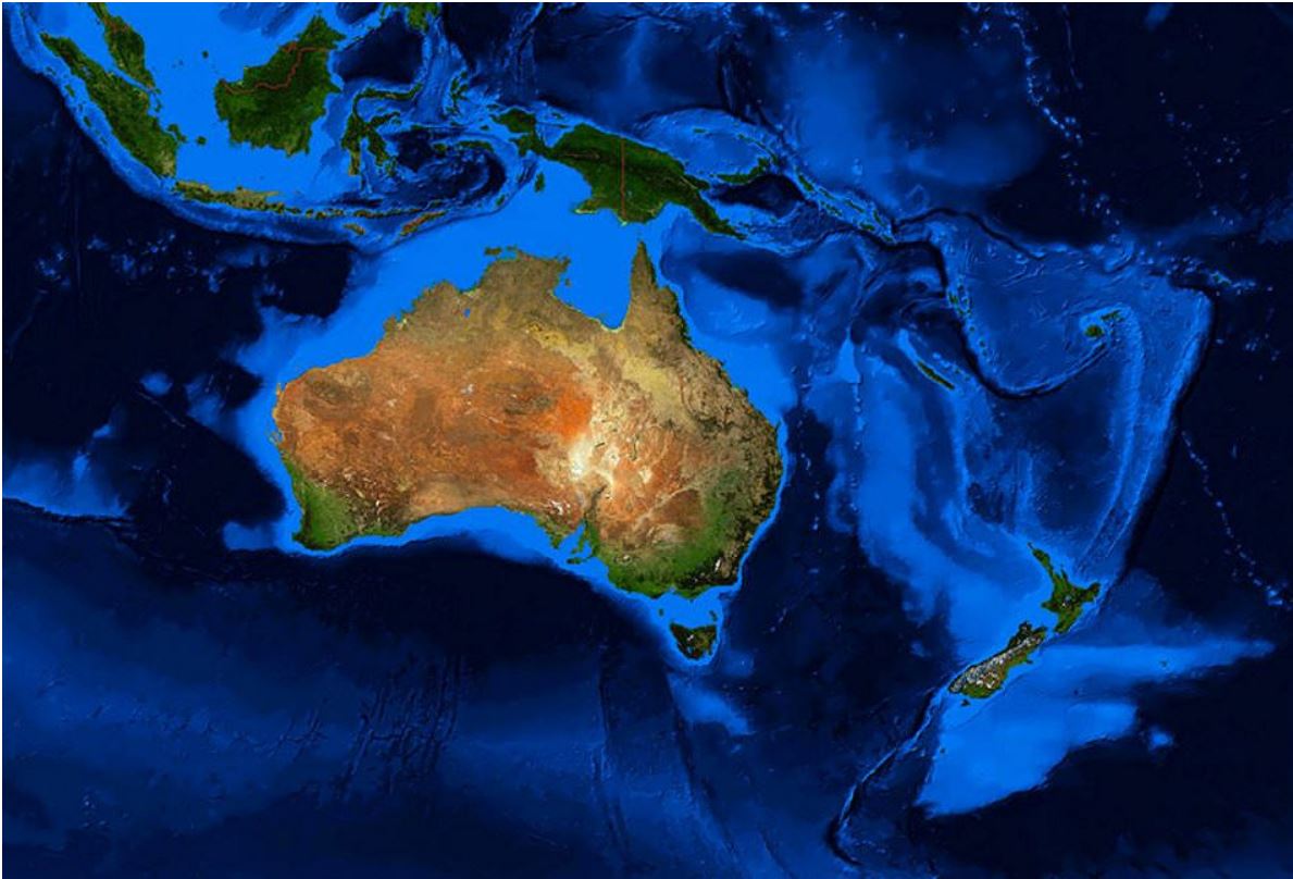
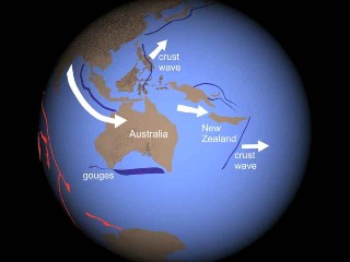
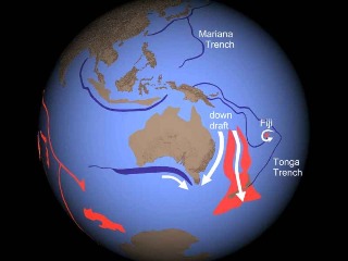
This view shows the clearest evidence of turbulence in the oceanic crust. As the block made up of India, Australia, Southeast Asia, and other islands hit Asia, it shattered, and the crustal wave divided. Pieces of the block were thrown eastward behind the crustal waves. The northern wave pulled the Philippines off of Borneo. Sumatra laid a trench behind Australia. As the waves advanced, counterclockwise turbulence in the crust behind the lower wave left a curved trench and created a downdraft. Australia and especially New Zealand were caught in the downdraft. Gouges trace how Eastern Australia dipped to the south. Fluidized crust, shown in red, flowed like a river with New Zealand and then past it, spreading out like a delta. The curved trench ended as a sort of shearing vortex that raised the islands of Fiji. The crustal waves froze, forming the Mariana and Tonga Trench systems.
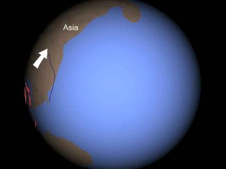
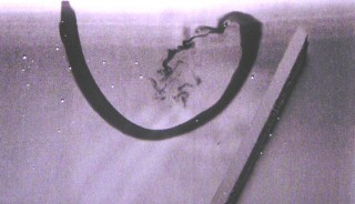
This demonstration (similar to the one on the previous page, presentation 14) shows how turbulence affected the fluidized oceanic crust. A wooden paddle is placed in a shallow pan of water, and a drop of food coloring is added.

Moving the paddle to the right makes the water behind it rotate counterclockwise.
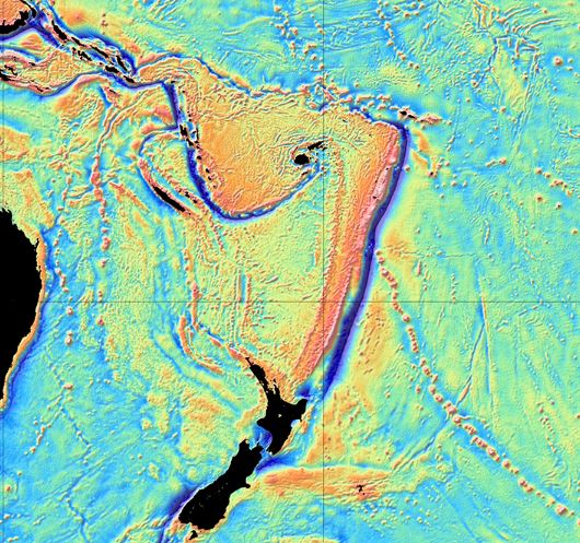
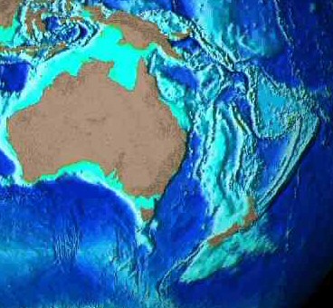
This is how the Tonga-New Hebrides region actually appears on the 2014 Sandwell marine gravity anomaly map derived from satellite altimetry.
Below
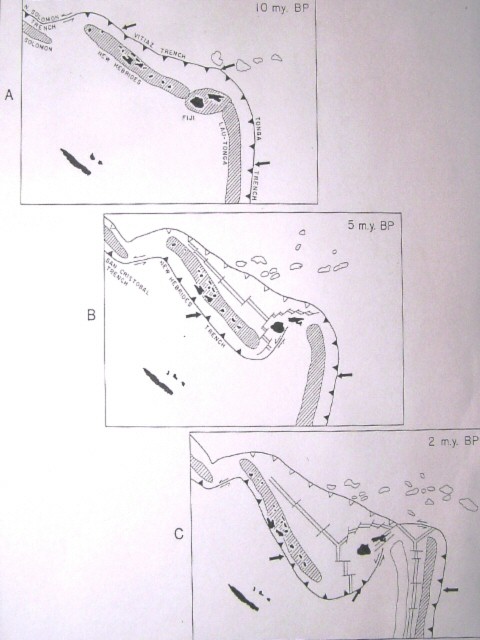
is the Plate Tectonics version of the formation of this region.
Subduction polarity (direction) reversed because 250 to
2,700 km to the west the plate hit the Ontong Java Plateau.
Various spreading ridges
emerged (for no particular reason) and opened the North
Fiji Basin. The full story of the spreading ridges is
even more complicated than shown, with new ones forming on
old ones at various angles. As Crawford
et al wrote, "The distribution and orientation
of spreading centres in the North Fiji Basin has been remarkably
transient with numerous microplates, parallel spreading ridges,
several unstable triple junctions, and probably leaky transform
faults."1
Which explanation is more straightforward? Decide for
yourself.
1.
Crawford, A.J., S. Meffre, P.A. Symonds. 2003. 120 to
0 Ma tectonic evolution of the southwest Pacific and analogous geological
evolution of the 600 to 220 Ma Tasman Fold Belt System. Geological
Society of America Special Paper 372, pp. 383-403.
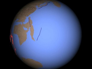
East of Australia, the long Lord Howe Rise "continental ribbon" reaches down to New Zealand. According to Plate Tectonics, it is a thin fragment of continental crust that split off of eastern Australia and sank to its current depth. Then, over 30 million years, most of New Zealand's southern island and the section south of New Zealand (Campbell Plateau and Chatham Rise) that look like an extension of the Lord Howe Rise, rotated in from the east so that today they are all perfectly aligned in a most convenient manner. Shock Dynamics tells a simpler and yet more remarkable story of the origin of this feature. Shown here is the "continental ribbon" (red) being formed out of turbulent, fluidized oceanic crust by the pull of New Zealand south in the down draft. The flow gains mass and speed as it goes. When New Zealand stops on the frozen wave (Tonga-Kermadec Trench), the flow rushes past it, spreads out, and stops.
Note the alluvial fan-shape south of New Zealand - the Campbell plateau.
|
|
|
|
| From the digital elevation map "Surface of the Earth", Peter W. Sloss, NOAA/NGDC, 1994. |
|
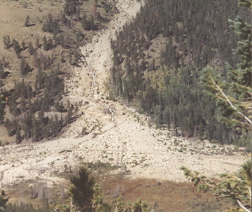
Alluvial
fan, Lawn Lake dam break 1980, |
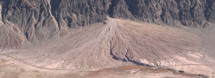
Alluvial fan, Wineglass canyon,
Death Valley, California
There
are substantial areas on the Earth that are not part of the 14 large
"plates" of Plate Tectonics theory that one hears so much
about. A study has found 38 additional "small plates"
plus a number of zones designated as "orogens" with fuzzy
plate boundaries. The largest "orogen"
stretches from Korea to the Alps. Another covers Alaska and
its connection with Canada. Most of the "small plates"
are in the region where the Australia-Southeast Asia block shattered
against Asia and scattered to the east. These exceptions to
the rule require special interpretation in Plate Tectonics theory,
and bring to mind the attempts to salvage the Earth-centered view
of the solar system by adding "epicycles" to the orbits
of planets in the days before Galileo.
Bird,
Peter. 14 March 2003. An updated digital model of plate boundaries.
Geochemistry Geophysics Geosystems (G3), Vol. 4, No. 3, 52 pages.
Now it's a "continent"! Geologists have decided that the outlined area in the picture below is a continent; they call it Zealandia.
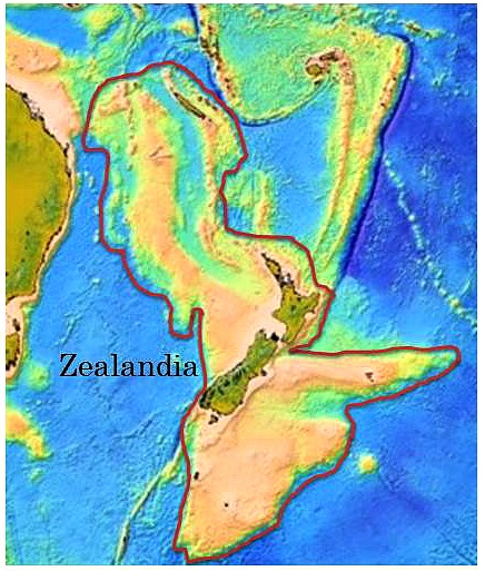
There
is enough thinned and stretched continental-type crustal rock to
distinguish it from oceanic crust. To qualify as a continent,
the crust has to 1) be elevated above oceanic crust; 2) consist
of siliceous continental rocks such as the Paleozoic and Mesozoic
greywacke, schist, and granite found throughout Zealandia; 3) cover
an area greater than 1 million square kilometers, as the 4.9 million
square kilometers of Zealandia does; 4) show continental crustal
structure: extended continental crust averages 30 km thick, compared
to the 7 km thickness of oceanic crust. Zealandia's crust
is in between, ranging from 10 to 30 km thick throughout except
for the South Island of New Zealand which is over 40 km thick, typical
for mountainous continental crust. Pressure (P) wave velocity,
measured with seismic tomography, for continental crust is 6.5 km/sec,
compared to 7.5 km/sec for the lower portion of oceanic crust. Again,
Zealandia's P wave velocity is in between, being generally less
than 7 km/sec.
Mortimer,
Nick, Hamish J. Campbell, Andy J. Tulloch, Peter R. King, Vaughan
M. Stagpoole, Ray A. Wood, Mark S. Rattenbury, Rupert Sutherland,
Chris J. Adams, Julien Collot, Maria Seton. March/April 2017. Zealandia:
Earth's Hidden Continent. GSA Today, Vol. 27, Issue 3, 8 pages,
DOI: 10.1130/GSATG321A.1
You have seen the Shock Dynamics explanation for the formation of this highly unusual region. Imagine how contorted the explanation will have to be to produce this new "continent" using Plate Tectonics' crude mechanisms.
Birds of a feather
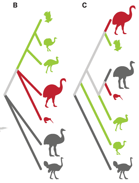
"Ratites have been believed to have originated through vicariant [geographically separated] speciation driven by the continental breakup of the supercontinent Gondwana". However, analysis of the mitochondrial genome of the elephant bird of Madagascar shows that it is the closest relative of the kiwi of New Zealand and distantly related to ostriches of Africa. Sticking with the Plate Tectonics story throws the evolution of flightless birds into complete confusion: "Early ratite evolution appears to have been dominated by flighted [i.e. flying] dispersal and parallel evolution, with flightlessness evolving a minimum of six times and gigantism a minimum of five."
On the other hand, the Shock Dynamics theory places Australia and New Zealand near to Madagascar at the start, and separates them to their present locations in less than two days. So the close relation of elephant birds and kiwis poses no problems at all.
Mitchell, Kieren J., Bastien Llamas, Julien Soubrier, Nicolas J. Rawlence, Trevor H. Worthy, Jamie Wood, Michael S. Y. Lee, Alan Cooper. 23 May 2014. Ancient DNA reveals elephant birds and kiwi are sister taxa and clarifies ratite bird evolution. Science, Vol. 344, No. 6186, pp. 898-900.
Even people and crops on Madagascar are Asian, not African
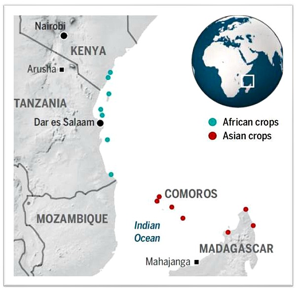
"The settlement of the Indian Oceans largest island is one of the great mysteries in humanitys colonization of the globe. Madagascar lies just 400 kilometers off the East African coast. Yet the Malagasy peoples cuisine, rituals, and religious beliefs resemble those of Borneo, some 9000 kilometers to the east. Their language is more closely related to Hawaiian than to Bantu, and about half their genes can be traced to Austronesia - that is, Indonesia and the islands of the Pacific."
Archaeologists "collected more than 2400 samples of botanical remains at 20 sites on the African mainland, on offshore islands, and on Madagascar." "Asian crops were common on the Comoros and on Madagascar, but rare on the East African coast."
Lawler, Andrew. 3 June 2016. 'Culinary frontier' tracks Madagascar's Asian settlers. Science, Vol. 352, No. 6290, pp. 1154-1155.
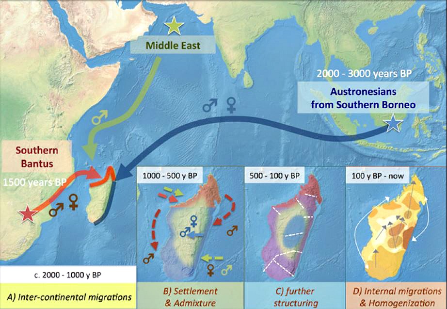
The image shows the estimated locations and dates of people who arrived on Madagascar; y BP = years before present. Researchers analyzed the genomes of 2,704 Malagasy people in 257 villages, finding "two main ancestries for the entire Malagasy population, namely Bantu from southeast Africa and Austronesians from Indonesia (in particular, south Borneo), with a very limited contribution from Europe and the Middle East." "The present Malagasy population shares recent common ancestors with Bantu and Austronesian populations now living 8,000 km apart." So did the original population sail 4,600 miles from south Borneo to Madagascar a thousand years before Africans sailed 250 miles to the same place? Or, as in the Shock Dynamics model, were the ancestors of people who occupy south Borneo already on the protocontinent near Madagascar before the giant impact, surviving in Madagascar's central highlands?
Pierron, Denis et al. August 8, 2017. Genomic landscape of human diversity across Madagascar. Proceedings of the National Academy of Sciences, Vol. 114, No. 32, E6498-E6506. DOI:10.1073/pnas.1704906114
![]()